| Directions
Take Exit 23 from I-87 and go west to US 9 in Warrensburg.
Take a right on US9 and go 0.8 mile, where you should turn
left on NY418. This road will become CR2 and will
end at a "T" just after crossing the Hudson River.
Take a left and then a quick right and you will be on Athol
Road/CR13. In a little over 3 miles, bear left on
the Valley Road/CR36. Continue until coming to the
Garnet Lake Rd S on your left. In one mile you will
come to a dirt road on your right (Ski Hi Road). Two
miles down this, you will find the trailhead.
|
| County: |
Warren |
| Town: |
Johnsburg |
| USGS Map: |
Johnsburg |
| Waterway: |
Crane Mountain Pond outlet |
| Latitude: |
N 43o 32' 42.18" |
| Longitude: |
W 73o 58' 43.32" |
| Drop: |
25' |
| Type: |
Cascade |
| Region: |
Off US 9 northwest of Warrensburg |
| Parking: |
Roadside |
| Trail type: |
Dirt |
| Length of hike: |
1.3 mile |
| Difficulty: |
Moderate |
| Accessibility: |
Public |
| Name: |
Unnamed |
|
Our thanks to Gary Dilmore for the information and pictures on
this location.
Take the Crane Mountain Trail out of the north end of the
parking lot. There is another trailhead out of the right
side of the parking lot, the East Trail, do not take this.
Twenty yards after the sign-in kiosk, take a left on the
Putnam Cut Across Trail and follow it 0.3 mile to the end.
Turn right on the Putnam Farm Road Trail and follow 0.7
mile to the waterfall which will be on your right.
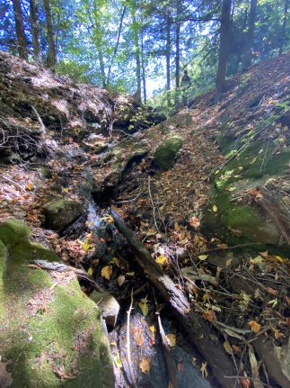
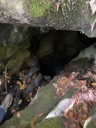
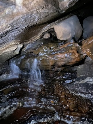
This waterfall is unique in that it drops about 15 feet over
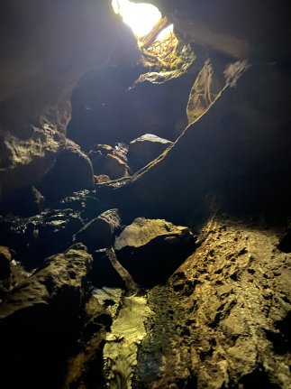
a 40' run and then "disappears" into a cave that runs
underneath the trail for about 30 feet. While
flowing through the cave there is a 6' drop followed by
another 4' cascade drop before the waterreappears
on the other side of the trail in what looks like a 20' deep
sinkhole. The water then disappears into another smaller
cave on the far side of the sinkhole. Total
drop of this falls up to the point that it enters the second
cave is 25' over a 80' distance.
Webmaster's note: When we were there in 2013, the
region was so wet, we couldn't even reach the falls.
When the Dilmores were there in 2025, the water was so low,
the cave was accessible. We want to note that we are
not suggesting or promoting that you should enter this cave. There is a six foot drop to enter
it and even at moderate water levels, your downstream
exit is blocked. You would have to have proper
equipment to exit via the six foot drop and even then, it
would be difficult.
Our pictures show how dry this
was in 2025. It doesn't even look like a waterfall.
A return trip is planned to get pictures with water flowing.
Webmaster's note: We found the roads in this area somewhat confusing. When
we were on the Ski Hi Road, for example, there was one sign that
called it the Sky Hi Road. To complicate things even more,
mapquest.com calls it Sky High Road. Garnet Lake Rd S became
Garnet Lake Rd, then Garnet Lake Rd N and back to Garnet Lake Rd
without warning. Also, there were a couple of intersections
on this one where you needed to turn to stay on the same road!
Note that continuing to hike up the trail will take you to the
Crane Mountain Cascade.
After flowing into Putnam Brook, this waterway heads
northwesterly and empties into Mill Creek. This flows
south through Garnet Lake, leaves that waterway through Madison
Creek and eventually joins East Stony Creek. Although
called a creek, this is fairly long and meets up with the Great
Sacandaga Lake in Hamilton County. The Sacandaga
River takes this water
to the Hudson River which it meets in Lake Luzerne and this
flows into the Atlantic in New York City.
Last update: October 9, 2025
|