Rivers in New York State
|
Any discussion
of waterfalls would have to include the waterway containing them.
Whether it be called a river, stream, creek, kill or something else, a waterfall
won't exist without the water that forms it. The New York State Department
of Environmental Conservation (DEC) website claims that there are over 70,000
miles of rivers and streams in New York. There are so many smaller
waterways that you might have a problem counting them all. Many of
them are unnamed. This page is dedicated to the longer rivers within
the state. We will offer a "Top Six" ... the six longest rivers in
the state. These are, however, not completely within the
boundaries of New York State because part of their waters are in an
adjoining state or the country of Canada.
|
The longest rivers
...
What are commonly viewed as the six longest rivers in the state are not
contained entirely within New York State. |
1 ... St. Lawrence River ... 744 miles, 108 in NY, all shared
by Canada |
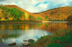
The St. Lawrence is generally considered
the longest river in New York. It begins at the outlet of the Great
Lakes on Lake Ontario at Tibbetts Point in Cape Vincent, New
York and flows to the Atlantic Ocean. Most sources list it at 744 miles.
Of this, only about 108 miles of it is in New York State.
Even these 108 miles are not entirely within New York State
because this stretch forms the international boundary with
Canada. Several
rivers that are completely contained in the state are longer than
this. Within this stretch is the Thousand Islands. Actually
over 1,800 islands, this is some of the prettiest scenery in the
country.
Photo credit: www.schryver.us |
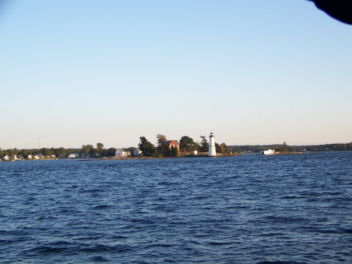
Rock Island
Lighthouse on the St. Lawrence River |
|
2 ... Susquehanna
River ... 464 miles, 136 in NY
|
The Susquehanna River |
At 464 miles, the Susquehanna, like the
St. Lawrence, is not entirely contained within the state.
Its source is the outlet of Otsego Lake in the Otsego County Seat
of Cooperstown, home to the Baseball Hall of Fame. It generally flows south and west before entering
Pennsylvania roughly 84 miles later in New York's Broome County.
It makes a loop in PA before returning to New York about eight miles
west of where it had exited the state. It meanders through
the New York Tri-Cities of Binghamton, Johnson City and Vestal before
re-entering Pennsylvania 52 miles later. With a total of 136
miles in the state, this would rank just behind what is generally
considered the ninth longest river in the state. It eventually
drains into the Atlantic Ocean at Chesepeake Bay.
Photo credit: visitcentralpa.org |
|
3 ... Allegheny River
... 325 miles, 35 in NY
|
At 325 miles, the Allegheny is a significant river. For
our discussion, not so much! Its source is in Potter County
PA, about 110 miles southeast of Erie. It ends in Pittsburgh
PA. Here is joins with the Monongahela River to form the Ohio
River. During its journey from start to finish, it flows through
only 35 miles of New York State in the extreme southwestern portion of
the state. Even though the river is long, the part of it
that is in New York State is fairly trivial.
Photo credit: allegheny.org |
The Allegheny River |
|
4 ... Hudson River
... 315 miles, the last 25 shared by
NJ |
Rockwell Falls on the Hudson in
Lake Luzerne |
Undoubtedly the most famous river in New York, at 315 miles,
it is also generally considered to be the longest river entirely
contained within the state. A purist might argue this.
It's true that it does start and end in New York State. Various
sources claim that it originates in the Mount Marcy area.
Since this is New York's highest point, many waterways probably
trace their routes there. Topographical maps first show it
just east of Henderson Lake in the Essex County town of Newcomb.
It empties into the Atlantic Ocean in New York City, but the last
25 miles of it forms the border with New Jersey so only part of
the end is in New York and part of the end is in New Jersey.
Since 290 miles of the Hudson is in New York State and not shared
by another state, it is the longest stretch in New York, but technically
it is not entirely within just New York. It is, however, the
first river on our list that contains waterfalls in Northern New
York. |
|
5 ... Delaware River
... 301 miles, relatively little in NY
|
The Delaware does start in New York State,
but this is another river where much of its 301 miles are not in
the state. In fact, there are two branches of the Delaware,
both starting in New York. The West Branch has its source
somewhere around the Stamford Reservoir in Schoharie County, just
north of the village of Stamford, which is in Delaware County.
The East Branch traces its roots to the town of Roxbury, on the
eastern end of Delaware County. The two branches join in Hancock,
New York which is on the Pennsylvania border. From here, the
next 80 miles of the Delaware forms the border with Pennsylvania.
The point at which New York, New Jersey and Pennsylvania meet is
actually in the Delaware River and this is where it exits the state.
The rest of it flows to the Atlantic Ocean at Delaware Bay With
less than 1.5 miles of the West Branch in Schoharie County and the
rest of the New York State portion of this river in Delaware County,
which borders Pennsylvania, very little of this is entirely within
New York.
Photo credit: state.nj.us |
Delaware River |
|
6 ... Genesee River
... 157 miles, an estimated 20 in PA
|
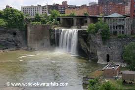
High Falls in Rochester on the Genesee
|
Generally considered to be 157 miles long, we found a website
that stated that this is the longest river contained entirely within
New York State. It then went on to say that it starts in Ulysses
Township, Pennsylvania. That one left us wondering how it
could be entirely within New York if its origin is in PA!
Granted, much of it is in the state. This one ends in Rochester,
New York at Lake Ontario.
Photo credit: world-of-waterfalls.com
|
|
Our Top Sixteen ...
Following is our "Top Sixteen" ... what we feel are the sixteen longest
rivers that are completely contained
within the state. Finally, we will list several other significant rivers. |
The focus of this website is the waterfalls
in the upper, or northern portion of New York State. As such, our
concern are the rivers containing those waterfalls. The next part
of this discussion will focus on the sixteen longest rivers that start,
end and are entirely contained within New York State. They never leave
the state and they are not shared by any border with another state or Canada.
We originally planned a Top Ten, but our research led us to sixteen rivers
that are entirely within the state, we decided to go wild! It is interesting
to note that all of these track their source to the Adirondacks. |
1 ... Mohawk River
... 150 miles
|
| Various sources list the Mohawk River at anywhere from 140 to
150 miles. As the seventh longest river in the state, we are
making the claim that this is the longest ... number one.
The Mohawk is the largest tributary of the Hudson. Its
West Branch starts in the Oneida County town of
Lee while the East Branch traces its roots to an
area just south of West Leyden, somewhere near the Lewis/Oneida
County line. They converge just west of the Lee/Western town
line in Oneida County. The merged river flows primarilly south
to Rome, New York where it continues its journey mainly east before
emptying into the Hudson in the Albany area. We consider this
not only the longest river contained entirely within New York State,
the stretch from Rome to Albany forms part of the southern boundary
of the region we include for waterfalls on this website. Pictured
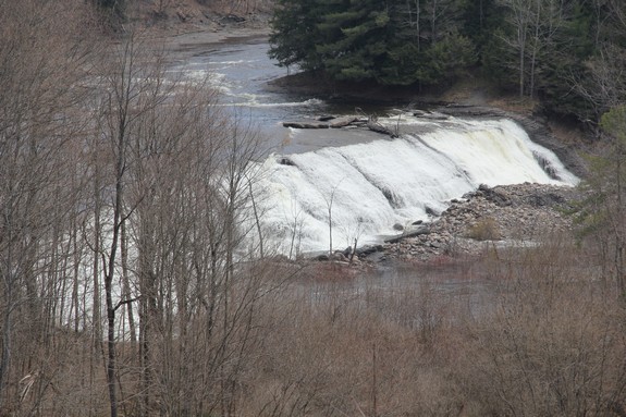
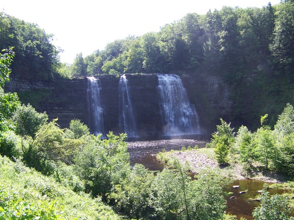
is Cohoes Falls, the largest waterfall on the Mohawk. |
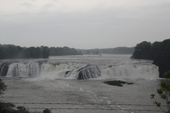
Cohoes Falls on the Mohawk River
|
|
2 ... Raquette River
... 146 miles
 Usually
considered the eighth longest river in the state, we rank this as
the second contained entirely within New York. It originates
in the Adirondack heartland at Raquette Lake which is located in
the Hamilton County town of Long Lake. For 146 miles, it flows
primarily north to the St. Franklin County town of Bombay.
Within the St. Regis Indian Reservation, it is here that it enters
the St. Lawrence River. As for our discussion of rivers located
entirely within New York State, you can't cut this one much closer.
The edge of the mouth of the Raquette is less than one mile from
the point at which the Canadian border goes from a water border
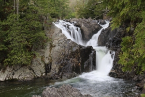
on the St. Lawrence to a land border. Pictured is Raquette
Falls which is located in Franklin County. Usually
considered the eighth longest river in the state, we rank this as
the second contained entirely within New York. It originates
in the Adirondack heartland at Raquette Lake which is located in
the Hamilton County town of Long Lake. For 146 miles, it flows
primarily north to the St. Franklin County town of Bombay.
Within the St. Regis Indian Reservation, it is here that it enters
the St. Lawrence River. As for our discussion of rivers located
entirely within New York State, you can't cut this one much closer.
The edge of the mouth of the Raquette is less than one mile from
the point at which the Canadian border goes from a water border
on the St. Lawrence to a land border. Pictured is Raquette
Falls which is located in Franklin County.
|
|
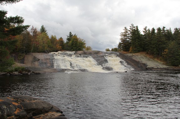
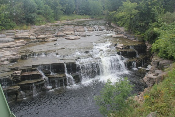
3 ... Oswegatchie
River ... 137 miles
|
At 137 miles, the Oswegatchie is the third longest river entirely
within the state. This river traces its roots to a number
of places in the Adirondack Mountains. The main branch originates
in Hamilton County, flows through Herkimer and St. Lawrence Counties
where it contains Cranberry Lake. The Middle Branch
starts in a myriad of lakes, most notably Willys and Walker Lakes
in the northeastern Herkimer County town of Webb. This is
a very remote area. This flows back and forth through St.
Lawrence and Herkimer Counties before joining the West Branch
just south of Harrisville in Lewis County. The West Branch
continues into St. Lawrence County where it connects to the Main
Branch in the town of Edwards, just east of the Fowler town line.
As the main channel makes its way to the St. Lawrence River in Ogdensburg,
it passes a lesser known portion known as the Island Branch
just southeast of Gouverneur.
Photo credit: Alice Galvin
|
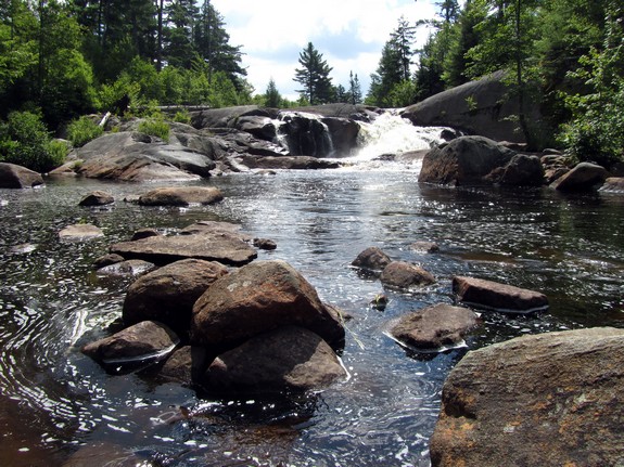
One of two High Falls on the Oswegatchie
|
|
4 ... Black River
... 125 miles |
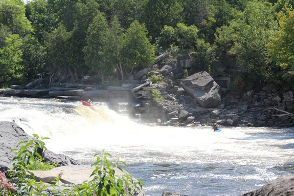
Kayakers at Glen Park Falls on the Black
|
In the neighborhood of 125 miles long, this river is the fourth
longest river entirely within the state. A relatively little
known fact is that, in addition to the main channel, there are
North, South and Middle Branches of the Black.
All three trace to very remote areas of central Herkimer County.
The North and Middle Branches both flow into North Lake. The
outlet of this is the main channel. The South Branch, which
starts at South Lake joins the main river also just south of North
Lake. From here it makes its way through Oneida, Lewis and
Jefferson Counties, where a number of significant rivers feed it.
The outlet of the Black is at Black River Bay, just west of
Watertown on Lake Ontario. The river in the Watertown area
is a whitewater playground. |
|
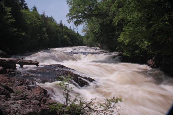
5 ... Ausable River
... 94 miles |
|
| The origin of the 94 mile long Ausable
involves the west and east branches. The West Branch
begins in the Essex County town of North Elba, just northeast of
Heart Lake. The source of the East Branch
is at Upper Ausable Lake, just upstream of the Adirondack Mountain
Reserve. Waterfalls abound on both of these waterways which
converge in Ausable Forks, which straddles the Clinton/Essex County
Line. The combined Ausable empties into Lake Champlain in
southeast Clinton County, but all but the last three miles or so
of this river is the county line. |
Alice Falls on the Ausable River
|
|
6 ... Saranac River
... 81 miles |
|
Cadyville Falls on the Saranac
|
At 81 miles long, the Saranac enters our list as the sixth longest.
The Saranac is another river that is formed by two branches, the
North Branch traces its roots to the Franklin County
town of Brighton. The main channel begins at Middle Saranac
Lake. This is just north of NY 3 in southern Franklin County.
The North Branch merges with the main channel within site of NY
3 by the hamlet of Clayburg. The combined river empties into
Lake Champlain on the south side of the city of Plattsburgh.
|
|
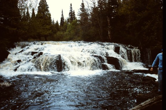
7 ... West Canada
Creek ... 76 miles |
| At 76 miles long, this "creek" is actually
a significant river and is number 7 on our list. It traces
its source to the West Canada Lakes in south-western Hamilton County.
From there it flows into Herkimer County where it is joined by the
South Branch near Nobleboro. This branch
flows mainly west from its source near Pine Lake, also in Hamilton
County. The combined creek flows through Hinckley Reservoir
where it becomes the county line between Oneida and Herkimer Counties
for about 15 miles. Near Poland, New York, it flows mainly
south and east until it reaches the Mohawk River in Herkimer, New
York. |
Prospect Falls on the West Canada Creek
|
|
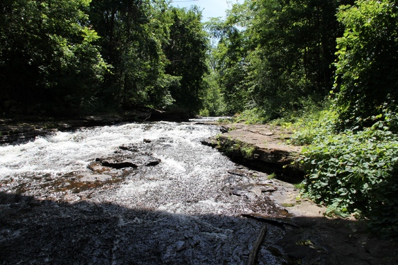
8 ... Grass River
... 70 miles |
Lampsons Falls on the Grass River
|
The Grass River has multiple sources. A unique claim for
this river is that, although it is 70 miles long, it not only is
entirely within New York State, it is entirely in one county, St.
Lawrence, geographically the state's largest. The South Branch
starts at the Grass River Flow, just off the south side of NY 3
between Cranberry Lake and Tupper Lake. The Middle
Branch originates in a fairly remote area of the county
in the town of Colton. These two join forces to form the main
channel just north of the hamlet of Degrasse in the town of Clare.
The North Branch, which starts just west of NY
56 not far from the Carry Falls Reservoir, joins the main channel
just east of the hamlet of Russell. The Grass terminates at
the St. Lawrence River in Massena. Officially, this is the
Grass River. It is listed on the USGS GNIS as such. Some sources label this
the Grasse. According to Cassidy Percoco, Collections
Manager at the St. Lawrence County Historical Association, "Based
on the information in Claims to Name: Toponyms of St. Lawrence
County by Kelsie B. Harder and Mary Smallman, it was originally
'La Grasse', and it looks as though the 'e' was mainly dropped in
official usage in the early 20th century - possibly an attempt to
streamline or modernize. In recent years, the 'e' has come
back, most likely due to groups like Grasse River Heritage that
promote a more historical view." |
|
9 ... Sacandaga
River ... 64 miles |
| Number nine on our list is the 64 mile
long Sacandaga River which originates at Lake Pleasant in southern
Hamilton County. A couple of branches feed this river.
The West Branch starts near Meco Lake in the Hamilton
County town of Benson. The North Branch starts
near Canary Pond which is not even two miles from Meco Lake, also
in Benson. The North Branch merges with the West Branch just
east of where NY 10 crosses the West Branch just north of the hamlet
of Arietta, very close to the Fulton County line. The West
Branch joins the main channel about two miles south of the village
of Wells/Lake Algonquin. The main channel continues through
the Great Sacandaga Lake and empties into the Hudson River at Hadley.
The Hudson at this point is the Saratoga/Warren County line and
Lake Luzerne is just across the river. |
Christine Falls on the Sacandaga
|
|
10 ... Deer River ... Franklin
to St. Lawrence Counties ... 53 miles
|
 |
Not to confuse things, there are two Deer Rivers in our region.
This one is way up north. It starts at Lake Florence, just
east of NY 30 in the Franklin County town of Duane. Almost
53 miles later, it flows into the St. Regis at the hamlet of Helena
in the St. Lawrence County town of Brasher. It contains two
waterfalls that we know of, both of which apparently must be reached
by canoe.
Photo credit: Don Feltham |
|
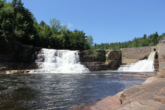
11 ... Moose River
... 52 miles |
| The 52 mile long Moose River is a very significant river.
This carries a lot of melting snow each spring, contains numerous
waterfalls and rapids and is a popular whitewater playground.
The North Branch originates at Big Moose Lake in
the Herkimer County town of Webb. Part of this lake is actually
on the Hamilton/Herkimer County line. The Middle Branch
begins at the Fulton Chain of Lakes' First Lake, just east of Old
Forge, also in the town of Webb. These two branches converge
just west of the village of Old Forge. The South Branch
traces its routes to Little Moose Lake in the Hamilton County town
of Arietta. These all meet in Webb, just upstream from the
hamlet of McKeever. This is located very near the point where
Herkimer, Lewis and Oneida Counties come together. The combined
Moose River empties into the Black in Lewis County at the village
of Lyons Falls. |
Whitewater and waterfalls abound on the
Moose |
|
12 ... Beaver River ...
Hamilton to Lewis Counties ... 47 miles
|
Taylorville Lower Falls
|
This river is 37 miles from its source at Lake Lila to the point
at which it flows into the Black River east of Castorland.
This is "as the crow flies". Considering all of the bends,
twists and reservoirs and lakes in its path, it is just over 47
miles long. It is the second longest tributary of the Black,
behind the Moose, detailed previously. It also has two short
branches, the North and South,
which both enter at Stillwater Reservoir. With several waterfalls
and many stretches of Class V rapids, this river is a whitewater
paradise. |
|
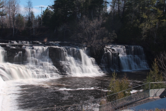
13 ... Salmon River ... Lewis
to Oswego Counties ... 44 miles
|
The most popular of
the three Salmon Rivers, probably because of its salmon fishing,
is the second longest at 44 miles. It flows through Oswego
County and is entirely contained with the state. The
North Branch, which starts in the town of Boyleston,
joins the main channel at the Salmon River Reservoir. The
main channel is formed in two places less than a mile apart and
then meander for several miles before joining together. All
three of these points are in the Lewis County town of Osceola.
The Salmon enters Lake Ontario just west of the village of Pulaski.
The most note-worthy waterfall on this waterway is the 110 foot
Salmon River Falls.
|
Salmon River Falls |
|
14 ... Boquet River ... Essex
County ... 40 miles |
Split Rock Falls on the Boquet
|
The Boquet starts and ends, and never leaves,
Essex County. Due to the French heritage in this area, it
was originally spelled Bouquet. In 1982, the Board on Geographic
Names changed the spelling. The North Fork originates just
north of Dix Mountain. The South Fork starts a short distance
away near Hough Peak. Both of these points are in the town
of Keene. These two converge about 170 feet into the town
of Elizabethtown near the intersection where NY 73 leaves US 9 at
the northern end of where they run concurrently. It empties
into Lake Champlain just east of the hamlet of Willsboro.
|
|
15 ... Deer River ...
Lewis County ... 27 miles |
| This is the second Deer River on our list.
The better known of two Deer Rivers, both of which are entirely
contained within the state starts in the town of Montague.
Twenty-seven miles and four waterfalls later, it flows into the
Black River just east of the hamlet of Deer River. This one
never leaves Lewis County. |
A waterfall, a hamlet and a river share
the name |
|
16 ... Oswego River
... 24 miles |
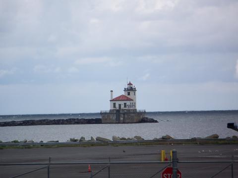
Oswego Pierhead Lighthouse at the mouth
of the Oswego River |
Although it is only 24 miles long, the Oswego has the distinction
of being the second largest river in Northern New York emptying
into Lake Ontario. It also is part of what we consider to
be the southern boundary of the region covered by this website.
There are five power dams on this river but no waterfalls.
We do not know if any of the hydro facilities were once falls.
Photo credit: www.schryver.us
|
|
17 ... Salmon River ... Clinton County
... 23 miles |
|
| This Salmon River is entirely contained within Clinton
County. Starting in the southern part of the county, it enters
Lake Champlain just south of the city of Plattsburgh. At a
bit less than 23 miles, it contains one notable waterfall. |
The Salmon River near Schuyler Falls
|
|
Other Significant
Rivers ...
|
There are several other rivers that are fairly significant,
either in terms of their length or because of the number of waterfalls on
them. The rest of our discussion focuses on these rivers that were
not included previously because, like the six longest rivers in the state, are
not entirely within the state boundaries. |
St. Regis River
... 86 miles, 1/4 mile in Canada! |
| At 86 miles long, the St. Regis could have claimed
the number six spot of rivers contained entirely within our the state if not for one small detail.
The last quarter-mile or so of it is not in New York. In fact, it
isn't even in the United States! This river traces its roots to the
Upper and Lower Saint Regis Lake in Franklin County. A number of significant
waterfalls are found between here and its outlet on the St. Lawrence River.
At the international border, only 0.9 miles separate these two rivers but
the outlet of it is less than one-quarter mile further. There might
be some that would argue about this one but most maps clearly label the
portion north of the border. In fact, in this region with strong French
influence, some of the maps indicate "Riviere St. Regis". |
Hoosic River
... 76 miles, about half in MA |
| The Hoosic River is generally recognized to be just
over 76 miles long which should put it in the above at the seventh spot,
the eighth if you consider the St. Regis we just mentioned. Our problem
with this one is that it starts in the Berkshire Mountains in western Massachusetts.
Only a portion of it is actually in New York. This river is significant
to us because a portion of it forms the border between Washington and Rensselaer
Counties which we consider the southern-most part of the territory covered
by this website in that section of the state. Any references found
to the Hoosac, Hoosick or Hoosuck Rivers are about the same waterway. |
Chateaugay River
... 75 miles, a few miles in Canada
|
| With a length of 75 miles, the Chateaugay would
also make our top group, but like the St. Regis, it starts in the Adirondacks
and ends in Canada. Its source is the Chateaugay Lakes along the Franklin/Clinton
County line. It crosses the international border just northwest of
the village of Chateaugay in Franklin County. A few miles later, its
flow turns to the northeast and it parallels the St. Lawrence for a distance
before joining it just south of Montreal. North of the border it is
often referred to by the French spelling Chateauguay. |
Tioga River
... 58 miles, most in PA |
| The 58 mile long Tioga is our first Southern Tier
river. This one starts in Bradford County, northern Pennsylvania.
It joins forces with the Cohocton River in the Painted Post/Corning area
of Steuben County. This is the start of the Chemung River. |
Chemung River
... 46 miles, most of it in PA |
| As just mentioned, this river starts at Painted
Post/Corning in Steuben County. It flows east and south and enters
Pennsylvania just southeast of Elmira. Only a mile-and-a-half or so
later it comes back into New York State. This 2.7 mile section again
enters our southern neighbor just west of Waverly. It then flows into
the Susuehanna River. Only a portion of its 46 miles are in New York. |
Salmon River
... only 49 miles of it in NY |
| This is one of the three Salmon Rivers in our region.
It is the longest and the only one not entirely contained within the state.
Originating at Elbow Ponds in the Catamount region of Franklin County, it
flows mainly north through Malone and exits into Canada at Fort Covington.
About 49 miles of this one is in the same county, but the rest of it flows
into the St. Lawrence in our neighbor to the north. There are two
waterfalls that we know of on this channel. |
Niagara River
... 35 miles, all shared with Canada |
| The 35 mile long Niagara River connects Lake Erie
with Lake Ontario and forms the international boundary with Canada in that
section of the state. Containing the state's best known waterfall,
Niagara Falls, this is not in the North Country. |
Any photo not credited was taken from this website. |

