| County: |
Essex |
| Town: |
North
Hudson |
| USGS Map: |
Paradox
Lake |
| Waterway: |
Berrymill Brook |
| Latitude: |
N 43°
58' 24.14" |
| Longitude: |
W 73°
39' 51.57" |
| Drop: |
~ 3' |
| Type: |
Cascade |
| Region: |
Northeast
of North Hudson |
| Parking: |
Unpaved
lot |
| Trail type: |
Dirt |
| Length of
hike: |
1.5 mile,
one-way |
| Difficulty: |
Easy |
| Accessibility: |
Public |
| Name: |
Unnamed |

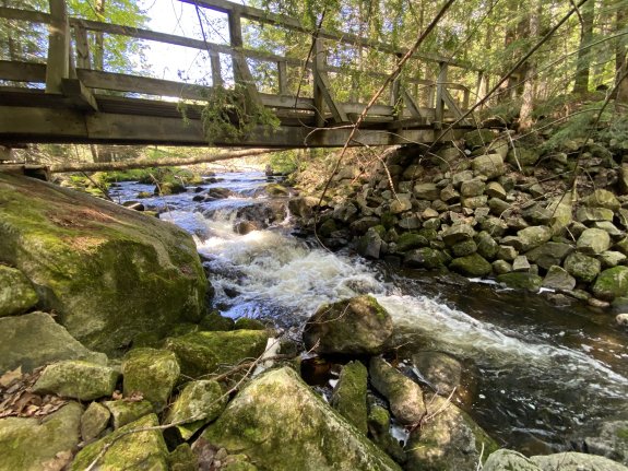
|
After enjoying
Berrymill Brook Falls,
continue on the trail for another half mile and you come to
Berrrymill Flow. There is a bridge over the stream that
exits the flow.
Some might not qualify this as
a waterfall but we've seen officially named falls that were
smaller! It's a very pleasant location and worth seeing.Berrymill Brook flows into Black Brook not far from
the trailhead of this hike. The water then flows west into
the Schroon River in the same general region of where you turned
off US 9 to get to this location. The Schroon flows south
through Schroon Lake and winds its way to the Hudson just west
of Warrensburg. The Hudson empties into the Atlantic Ocean
in New York City.
Last update: July 3, 2025
|