| Directions
Fron North Hudson in Essex County, take US 9 north.
Roughly 1.7 miles past the town hall and fire department
buildings, CR 40 will bear off to the right of US 9.
Ensign Pond Road will exit right from this short loop.
|
| County: |
Essex |
| Town: |
North
Hudson |
| USGS Map: |
Paradox
Lake |
| Waterway: |
Berrymill Brook |
| Latitude: |
N 43°
58' 45.49" |
| Longitude: |
W 73°
40' 01.67" |
| Drop: |
~ 6' |
| Type: |
Cascade |
| Region: |
Northeast
of North Hudson |
| Parking: |
Unpaved
lot |
| Trail type: |
Dirt |
| Length of
hike: |
1.0 mile,
one-way |
| Difficulty: |
Easy |
| Accessibility: |
Public |
| Name: |
Unnamed |

|
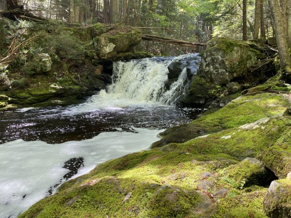
Continue on Ensign Pond Road to the Hammond Pond Trailhead.
Once on the trail, follow the
Berrymill Flow Trail which continues on to Moose Mountain Pond
Trail. It follows along Berrymill Brook which flows
through
Berrymill Flow. Some maps note this as Berrymill Pond.
About a half mile into
this fairly easy hike you come to pond with a cool beaver dam. At this
point the trail goes around the right side of the pond. At
one mile from the trailhead, right along side the trail you
will come to the waterfall, cannot miss it. It is only
about 6' but beautiful as you can see in the photo.
Berrymill Brook flows into Black Brook not far from
the trailhead of this hike. The water then flows west into
the Schroon River in the same general region of where you turned
off US 9 to get to this location. The Schroon flows south
through Schroon Lake and winds its way to the Hudson just west
of Warrensburg. The Hudson empties into the Atlantic Ocean
in New York City.
Last update: July 3, 2025
|