| Directions
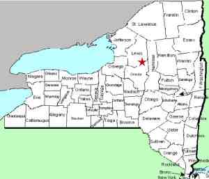
This waterfalls is located on the west side of NY 12,
1.1 miles north of the northernmost traffic light in the
village of Port Leyden.
|
| County: |
Lewis |
| Town: |
Leyden |
| USGS Map: |
Port Leyden |
| Waterway: |
Unnamed waterway |
| Latitude: |
N 43° 35' 42" |
| Longitude: |
W 75° 21' 31" |
| Drop: |
91' |
| Type: |
Ribbon cascade |
| Region: |
North of the
village of Port Leyden |
| Parking: |
Roadside |
| Trail type: |
Dirt |
| Length of hike: |
1 minute |
| Difficulty: |
Easy |
| Accessibility: |
Roadside |
| Name: |
Unnamed |

|
 This
unnamed waterfall on an unnamed stream can be seen from the side
of NY 12 as described in the directions side-bar. Note
that you have to cross railroad tracks to reach the base of the
falls. This
unnamed waterfall on an unnamed stream can be seen from the side
of NY 12 as described in the directions side-bar. Note
that you have to cross railroad tracks to reach the base of the
falls.
Although unnamed, the stream is charted but could very
well be primarily run-off. Having said that, this is a
significant drop. We estimated the height based on
topographical maps. Our pictures were taken in May 2019.
This was an especially rainy and wet spring. We will try
and check this location out later in the year to see how much
water is flowing at that time.
Until we learn differently, we are dubbing this Hells Kitchen
Road Falls. There are no significant landmarks in this
immediate area and, although it is not on that road, the two
sources of this creek start in reasonable proximately with the
upper end of that road.
If anyone has any additional information on this location, we
would very much like to hear from you. Please contact us.
This unnamed stream empties into the Black River about 3/4 of
a mile from here. The Black River empties into Lake Ontario at Black River
Bay, just southwest of the village of Dexter.
Last update: May 20, 2019
|


