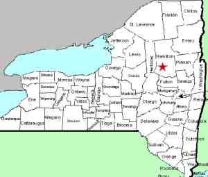
| Directions
From the intersection of NY 8 and NY 10
just south of Piseco Lake, travel northeast on NY 8 for
about 3.3 miles. Take the left on Old Piseco Road.
Just past the airport, the Haskells Road will exit right.
The trailhead for this hike is in that area.
|
| County: |
Hamilton |
| Town: |
Arietta |
| USGS Map: |
Piseco Lake |
| Waterway: |
T Lake outlet |
| Latitude: |
N 43°
27' 23" |
| Longitude: |
W 74°
36' 47" |
| Drop: |
500-600' |
| Type: |
Ribbon cascade |
| Region: |
West of the
hamlet of Piseco |
| Parking: |
Unpaved lot |
| Trail type: |
Dirt |
| Length of
hike: |
5 mile one-way |
| Difficulty: |
Difficult |
| Accessibility: |
Public |
| Name: |
Official |

|
Since we have not yet
been to this waterfall, we want to clarify that our directions have
been taken from maps. We know, however, that the trip is possible
because we have been in contact with, and have received pictures
from, people who have done it. The hike is five miles, one-way,
so terrain maps of the area would be in order.
Depending upon the source, this waterfall has a drop of between
500 and 600 feet, which makes it the tallest in the Adirondacks
and perhaps the entire state.
Our thanks to Vince Spadaro and Matthew Dawson, who are part
of a group that hikes this region often. Matt is also webmaster
of their website,
ftroop1968.com,
who has granted us permission to use their photos.
T Lake outlet flows into the South Branch of the West Canada
Creek. This joins the main branch which empties into the Mohawk
River at Herkimer. This flows to the Hudson River which empties
into the Atlantic Ocean in New York City.
Last update: October 11, 2016
|


