| Directions
In the village of Star Lake, NY 3 runs east-west through
the area. At the eastern end of the hamlet, Youngs Road
exits NY 3 south. There is a convenience store on this
corner. About 1/4 mile beyond the bridge over
Little River, just before the end of the road, there is a state land parking area. |
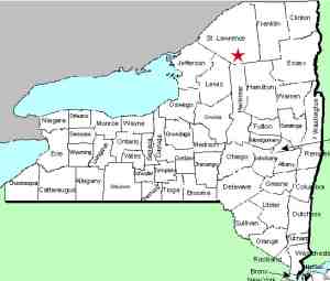
| County: |
St.
Lawrence |
| Town: |
Fine |
| USGS Map: |
Oswegatchie |
| Waterway: |
Tamarack
Creek |
| Latitude: |
N 44°
07' 25" |
| Longitude: |
W 75°
02' 28" |
| Drop: |
5' |
| Type: |
Slide to a cascade |
| Region: |
The hamlet
of Star Lake |
| Parking: |
Unpaved parking
lot |
| Trail type: |
Significant amount of bush-whacking, creek rock
hopping |
| Length of
hike: |
At least 6
miles, estimated, round-trip |
| Difficulty: |
Fairly
difficult |
| Accessibility: |
Public |
| Name: |
Common |

|
We will start with a couple of things. We learned of this
waterfall back around 2008 but it is quite remote and difficult
to get to. It is a fairly intense
hike. It is all on state land but involves a significant amount
of bush-whacking and traversing wet areas and creeks. Next, our
information was sent to us by a contributor who grew up in that
area and still spends quite a bit of time there. Our thanks to
the webmaster's nephew, Jim Laurin for his info and pictures.
From the parking area, follow the red marked
equestrian/snowmobile trail for 2.2 miles until you reach the
second bridge. This was flooded out by beaver dams in 2021.
Then go left and bush whack along the left side (river right)
of the feeder stream until you reach Tamarack Creek. From here,
wade upstream until you get to the falls. It has been described
as "a very difficult hike and rough terrain." You will get wet
so be prepared.
The Tamarack Creek feeds the Little River. Please note
that there are two Little Rivers in St. Lawrence County.
The other one is in the Canton area and is a tributary of the
Grasse River. This one empties into the Oswegatchie River
which flows to the St. Lawrence River in Ogdensburg.
Last update: September 25, 2021
|


