| Directions
In the hamlet of Parishville, Mill
Street exits the northwest side of NY 72. Very
soon after entering this street take a left into the
parking area.
|
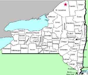
| County: |
St Lawrence |
| Town: |
Parishville |
| USGS Map: |
Parishville |
| Waterway: |
St. Regis
River West Branch |
| Latitude: |
N 44°
37' 40" |
| Longitude: |
W 74°
48' 58" |
| Drop: |
20' |
| Type: |
Flume |
| Region: |
In the village of Parishville |
| Parking: |
NA |
| Trail type: |
NA |
| Length of
hike: |
NA |
| Difficulty: |
NA |
| Accessibility: |
Private |
| Name: |
Common |

|
This unnamed waterfall is located in the hamlet of
Parishville. On the northwest side of the highway, you can
see a dam at this location. Below the dam is a very nice
flume type waterfall known locally as The Gorge.
On May 19, 2019, we received an email from a contributor that
Brookfield Hydro, who now owns the property, has closed this
area to the public. There are now fences placed which
prohibit access to the waterfall area.
This area is one of dozens of waterfall locations throughout
the north country that has long been a congregating spot for the
youth of the area. Stories of "The Gorge" are nothing
short of legendary.
The West Branch of the St. Regis River flows into the main channel
in Winthrop. The St. Regis River then flows to the St. Lawrence
River almost on the US/Canada border a few miles northeast of Massena,
New York.
Last update: May 20, 2019
|


