| Directions
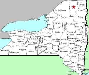
On NY 30 between Malone and Paul Smiths,
just north of the NY 458 intersection, you will encounter
the Meacham Lake State Park. Park in the parking
area at the extreme southern end of the lake, just north
of where the highway crosses the St. Regis River, East
Branch.
|
| County: |
Franklin |
| Town: |
Duane |
| USGS Map: |
Meacham Lake |
| Waterway: |
St. Regis
River East Branch |
| Latitude: |
N 44°
33' 13" |
| Longitude: |
W 74°
18' 35" |
| Drop: |
15' |
| Type: |
Stepping slides |
| Region: |
NY 30
south of Malone |
| Parking: |
Unpaved lot |
| Trail type: |
Dirt/rock |
| Length of
hike: |
<0.1 mile |
| Difficulty: |
Easy |
| Accessibility: |
Public |
| Name: |
Unnamed |

|
 Next to this parking area, there is a retaining dam at the outlet
of Meacham Lake. This is the beginning of the East Branch
of the St. Regis River. Across the highway from here, you
will find a very pleasant slide-type waterfall, that drops in three
or four sections. Next to this parking area, there is a retaining dam at the outlet
of Meacham Lake. This is the beginning of the East Branch
of the St. Regis River. Across the highway from here, you
will find a very pleasant slide-type waterfall, that drops in three
or four sections.
There are many unnamed waterfalls on the St. Regis. We
have dubbed this Meacham Falls because of its location at the outlet
of the lake and at the beginning of this branch of the river.
The East Branch joins the main channel of the St. Regis River
not far downstream from here, just below the hamlet of Santa Clara.
This flows to the St. Lawrence River almost on the US/Canada border
a few miles northeast of Massena, New York.
Last update: May 9, 2016
|


