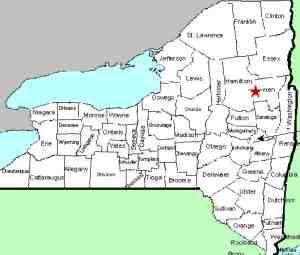
| Directions
From the junction of NY 8 and NY 30
north of Wells, go east on Route 8 for about 8.6 miles.
There is a parking area on the south side of the
highway. There is also a sign for
Cod Pond on the opposite side of the road.
|
| County: |
Warren |
| Town: |
Thurman |
| USGS Map: |
Bakers Mills |
| Waterway: |
Stewart Creek |
| Latitude: |
N 43°
31' 13" |
| Longitude: |
W 74°
08' 08" |
| Drop: |
15' |
| Type: |
Slide |
| Region: |
NY 8 between
Wevertown and the Hamilton/Warren County line |
| Parking: |
Roadside |
| Trail type: |
Dirt |
| Length of
hike: |
2.1 miles,
round-trip |
| Difficulty: |
Moderate |
| Accessibility: |
Public |
| Name: |
Unnamed |

|
 The trailhead is a short distance west of the parking area. About 0.2 miles down the trail you will
come to a junction of two trails. The right trail goes to
Cod Pond. After signing in at the kiosk at this point,
proceed straight. A sign there indicates that Stewart
Creek is in that direction. In another 0.8 miles until you reach
a wooden bridge. The waterfall starts under this bridge
and continues downstream. We note a 2.1 mile round-trip.
This accounts for the fact that you will probably want to cross
the bridge and descend to the creek bed where you can walk
downstream to get a better view and pictures. The trailhead is a short distance west of the parking area. About 0.2 miles down the trail you will
come to a junction of two trails. The right trail goes to
Cod Pond. After signing in at the kiosk at this point,
proceed straight. A sign there indicates that Stewart
Creek is in that direction. In another 0.8 miles until you reach
a wooden bridge. The waterfall starts under this bridge
and continues downstream. We note a 2.1 mile round-trip.
This accounts for the fact that you will probably want to cross
the bridge and descend to the creek bed where you can walk
downstream to get a better view and pictures.
This slide type falls, drops about 15' over a stretch of this
waterway.
Stewart Creek flows into the east branch of the Sacandaga River,
which joins the main branch downstream from that point. The
Sacandaga River flows through a number of lakes as it makes its
way to the Hudson River whose final destination is the Atlantic
Ocean.
Last update: July 27, 2021
|


