| Directions
From I-81 exit 39 (Mannsville) head west on CR 90.
At the end of this, take a right on CR 87. When
this ends in the hamlet of Ellisburg, go left, cross the
river and take the first right on Main Street. As
you leave the hamlet, Monitor Mill Road will exit
right. Just before crossing the South Sandy
Creek there is a DEC fishing access site parking lot on
the left. Park here.
|
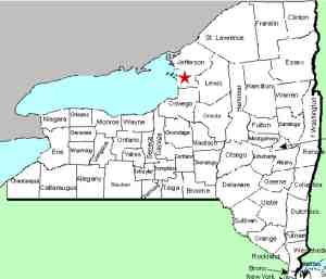
| County: |
Jefferson |
| Town: |
Ellisburg |
| USGS Map: |
Sandy Creek |
| Waterway: |
South Sandy Creek |
| Latitude: |
N 43°
44' 43" |
| Longitude: |
W 76°
07' 38" |
| Drop: |
20' |
| Type: |
Rectangular
Cascade |
| Region: |
West of
Mannsville |
| Parking: |
Unpaved lot |
| Trail type: |
Roadside |
| Length of hike: |
Roadside |
| Difficulty: |
Easy |
| Accessibility: |
Private |
| Name: |
Common |

|
 The waterfall is just upstream of the bridge adjacent to the
parking area. According to tax maps, this is on private
property. It is probably owned by a large farm just up the
road. You have a good view of the waterfall from the
bridge. The only problem is a large pipe that is suspended
across the river on the upstream side of the bridge. That
does impede your view. The waterfall is just upstream of the bridge adjacent to the
parking area. According to tax maps, this is on private
property. It is probably owned by a large farm just up the
road. You have a good view of the waterfall from the
bridge. The only problem is a large pipe that is suspended
across the river on the upstream side of the bridge. That
does impede your view.
Please note that as a DEC fishing
access site, anglers have the right to access the river for the
sole purpose of fishing. This right does not extend to any
other activity, such as waterfalling. We are not saying
that this is right, but that's the way the rule reads.
The South Sandy Creek flows into Lake Ontario.
Last update: April 14, 2017
|


