| Directions
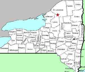
Just east of the hamlet of Pitcairn, which is east of
Harrisville, the Grahan Road will be on the southern
side of NY 3. This road is only 1.4 mile long and
both ends of it intersect NY 3. It is quicker to
take the more easterly end. Within 500 feet of NY
3, your first left will be the Skelly Haul Road.
In about 0.4 mile, you will come to a creek. Park
here.
|
| County: |
St. Lawrence |
| Town: |
Pitcairn |
| USGS Map: |
Fine |
| Waterway: |
Snyder Lake Feeder |
| Latitude: |
N 44° 12' 11" |
| Longitude: |
W 75° 13' 01" |
| Drop: |
8' |
| Type: |
Ribbon Cascade |
| Region: |
Off NY 3 between Harrisville and Fine |
| Parking: |
Dirt road |
| Trail type: |
Dirt |
| Length of hike: |
<
0.5 mile, one-way |
| Difficulty: |
Easy |
| Accessibility: |
Public |
| Name: |
Unnamed |

|
Let's start with a word of caution about the Grahan Road.
About mid-way between the two ends of it, there is another short
spur exiting the south side of NY 3. This may also be
labeled Grahan Road. Be certain as you encounter the first
intersection coming from the hamlet of Pitcairn that you drive
about 1.4 miles before making this right hand turn.
This section is part of the Greenwood Creek State Forest.
From the parking location, there is a gulf or ravine about 100
yards north of the road. This is fairly deep, and when you
reach it, the falls will be upstream on your right. It is
likely that the falls are actually on private property but the
state land runs within about 30 yards of the falls so you can
get close enough for viewing from public land.
The lower
falls are about 100 feet or so downstream of this one.
Our thanks to Bill Hill of
hikingthetrailtoyesterday.com for pictures and information
on this waterfalls.
This unnamed stream feeds Snyder Lake which in turn flows into Big Creek.
This subsequently finds its way into the
West Branch of the Oswegathchie River which joins the main
channel of the Oswegatchie near the hamlet of Talcville in the town
of Edwards. From here it flows into the St. Lawrence River
in Ogdensburg.
Last update: May 8, 2020
|


