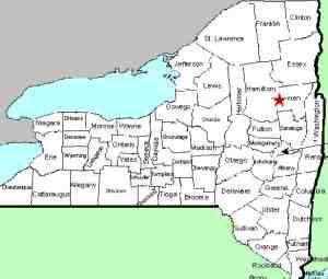
| Directions
From the junction of NY 8 and NY 30
north of Wells, go east on Route 8 for about 9.0 miles.
There is a parking lot on the right. This is about 3.1
miles past the county line. If traveling from
the east, this is 14.4 miles from the intersection of NY
8 and NY 28 in Wevertown.
|
| County: |
Warren |
| Town: |
Johnsburg |
| USGS Map: |
Bakers Mills |
| Waterway: |
Shanty Brook |
| Latitude: |
N 43°
33' 18" |
| Longitude: |
W 74°
09' 06" |
| Drop: |
6' |
| Type: |
Rapids/cascade |
| Region: |
NY 8 between
Wevertown and the Hamilton/Warren County line |
| Parking: |
Unpaved parking
lot |
| Trail type: |
Dirt |
| Length of
hike: |
1.5 mile,
one-way |
| Difficulty: |
Moderate |
| Accessibility: |
Public |
| Name: |
Unnamed |

|
From the parking area, proceed on foot for about 0.1 mile north
on route 8. There is a dirt road on the left. Follow
this to a point where you can see Shanty Brook entering the Sacandaga.
Climb down the embankment and ford
the river here. This hike is best done in
mid to late summer when the water levels are lower.
In an attempt to find the fairly popular Shanty Brook Falls,
we encountered many sections of the trail where Poison Ivy was
present. We opted to rock hop up the creek. We
ultimately went well past Shanty Brook Falls and at a little over 1.3
miles from the river crossing, we found the pictured lcation.
Only about a six foot drop, it flowed in an ess pattern through
the stream bed ... many might call it rapids. It is
certainly not nearly as impressive as Shanty Brook Falls but was
a nice hike.
Shanty Brook flows into the east branch of the Sacandaga River,
which joins the main branch downstream from that point. The
Sacandaga River flows through a number of lakes as it makes its
way to the Hudson River whose final destination is the Atlantic
Ocean.
Last update: September 11, 2021
|


