| Directions
Drive south on NY 12 from Lowville and
about 3.4 miles from the McDonalds, turn right on the Whitaker
Road. The first left will be the Jantzi Road.
This road ends on the Glendale Road, CR 32, where you should
turn left. Just past the entrance to the Whitaker
Falls Park, you will cross the Roaring Brook. This
small waterfall will be on your right.
|
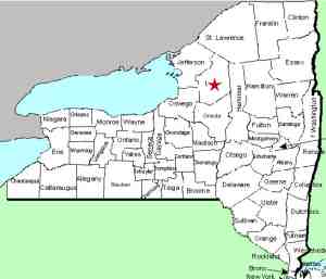
| County: |
Lewis |
| Town: |
Martinsburg |
| USGS Map: |
Glenfield |
| Waterway: |
Roaring Brook |
| Latitude: |
N 43°
43' 48" |
| Longitude: |
W 75°
27' 09" |
| Drop: |
10' |
| Type: |
Rectangular
Block |
| Region: |
South of Lowville |
| Parking: |
Roadside |
| Trail type: |
Roadside |
| Length of
hike: |
1 minute |
| Difficulty: |
Easy |
| Accessibility: |
Public |
| Name: |
Unnamed |

|
 This unnamed waterfall is within view of the highway.
This location is just upstream from Whitaker Falls in Whitaker Falls
Park. There is another waterfall about a mile-and-a-half downstream
from this point. Also unnamed, we have dubbed that one the
Roaring Brook Lower Falls. The very popular Whitaker Falls
is between these two waterfalls. This unnamed waterfall is within view of the highway.
This location is just upstream from Whitaker Falls in Whitaker Falls
Park. There is another waterfall about a mile-and-a-half downstream
from this point. Also unnamed, we have dubbed that one the
Roaring Brook Lower Falls. The very popular Whitaker Falls
is between these two waterfalls.
All of our photos were taken from the roadway.
Although we have not pursued this, we suspect that the property
surrounding this is private. That is really not an issue,
because unobstructed views are possible from the highway right-of-way.
The Roaring Brook flows into the Black River about
2.5 miles from this site. The Black River meets Lake Ontario
just west of Watertown in Dexter, New York.
Webmaster's note: We have had this
waterfall listed for some time as Roaring Brook Upper Falls.
We recently have become aware of another unnamed waterfall
further upstream on Roaring Brook. This makes "Upper
Falls" somewhat deceiving. Therefore, we have assigned a
more descriptive name to this one and have dubbed the new one
Upper Falls.
Last update: July 15, 2017
|


