| Directions
Head out of Potsdam on NY 56 north
toward Norwood. You will cross a railroad track
and the next left, Sissonville Road, will take you to
Unionville. As you approach the hamlet, the road
will bear left. This is actually the area where
the Unionville Dam is. Continue on the Sissonville
Road and the first right will be the Hewittville Road.
As you come to the river, park on the shoulder.
|
| County: |
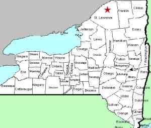
St. Lawrence |
| Town: |
Potsdam |
| USGS Map: |
West Potsdam |
| Waterway: |
Raquette River |
| Latitude: |
N 44°
50' 02" |
| Longitude: |
W 74°
58' 50" |
| Drop: |
NA |
| Type: |
Rapids |
| Region: |
North of Potsdam |
| Parking: |
Roadside |
| Trail type: |
Dirt |
| Length of
hike: |
3 minutes |
| Difficulty: |
Easy |
| Accessibility: |
Public |
| Name: |
Common |

|
If the water isn't too high, you can cross the road and stroll
down to the river bank. Walk up the river bank a few hundred
yards and you will see the dam. You can also cross the bridge
and there will be a parking/picnic area on your left. The
dam can be seen from here, but the views are that clear.
We do not know if there was a waterfall at this location
before the dam was constructed. If anyone has information on
the history of this area or perhaps a picture of a waterfall
that may have existed, please
contact us.
The Raquette River empties into the St. Lawrence River in Massena,
New York.
Last update: July 26, 2016
|


