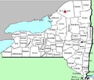
| Directions
The hamlets of Russell and Edwards
are joined by CR 24. Near the Russell end, CR17
exits. One-half mile from this corner is the access
road to Plumb Brook Falls, which is
clearly marked as the "Plumb Brook
Fishing Access Site".
|
| County: |
St. Lawrence |
| Town: |
Russell |
| USGS Map: |
Hermon |
| Waterway: |
Plumb Brook |
| Latitude: |
N 44°
23' 52" |
| Longitude: |
W 75°
08' 59" |
| Drop: |
15' |
| Type: |
Ribbon Cascade |
| Region: |
South of Canton |
| Parking: |
Unpaved lot |
| Trail type: |
Dirt |
| Length of hike: |
2 minutes |
| Difficulty: |
Easy |
| Accessibility: |
Public |
| Name: |
Official |

|
 Technically unnamed, these
falls are located on the Plumb Brook in the town of Russell.
The access road is is on CR 17,
½ mile from the junction of CR 17 and CR 24. The drive
down the access road is less than a tenth of a mile and there is
a small parking area. Head downstream and within a minute
or so, you are at the falls. Technically unnamed, these
falls are located on the Plumb Brook in the town of Russell.
The access road is is on CR 17,
½ mile from the junction of CR 17 and CR 24. The drive
down the access road is less than a tenth of a mile and there is
a small parking area. Head downstream and within a minute
or so, you are at the falls.
The name of this waterfall
is now official, having been added to the GNIS data base on
November 9, 2017.
Plumb Brook shouldn't be confused with the Plum Brook, also in
St. Lawrence County. That waterway is in the Potsdam area
and feeds the Raquette River in the town of Norfolk. We
know of no waterfall on that brook.
The Plumb Brook flows into the Grasse River which flows to the
St. Lawrence River in Ogdensburg, New York.
Last update: November 14, 2017
|


