| Directions
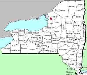
This waterfall is on private property, just west of Watertown near the hamlet
of Limerick, NY, not far from where NY 12E and NY
180 intersect.
|
| County: |
Jefferson |
| Town: |
Brownville |
| USGS Map: |
Dexter |
| Waterway: |
Perch River |
| Latitude: |
N 44°
01' 35" |
| Longitude: |
W 76°
03' 04" |
| Drop: |
15' |
| Type: |
Block |
| Region: |
Northwest
of the city of Watertown |
| Parking: |
NA |
| Trail type: |
NA |
| Length of
hike: |
NA |
| Difficulty: |
NA |
| Accessibility: |
Private |
| Name: |
Unnamed |

|
This waterfall is on private property. Even if it weren't,
it would be a serious challenge to reach it. We have
talked with the owners and it was common, back in the day, to
get down on the shore below it. Today, however, the
foliage and growth on the banks have become so thick, that
getting through it would be difficult.
We have permission
to go to this site and plan to do so at some point. When
we do, we will probably photograph it by drone.As the first
picture in the array indicates, there was a mill at this
location back in the early 1900s. This photo was captioned
"Falls of Perch River at Limerick early 1900s."
A little over 1/2 mile below this is an area where the
river flows underground for almost 1/2 mile. This area is
known locally as Natural Bridge.
The Perch River empties into the Black River Bay about two
miles downstream from this waterfall. This bay is a fairly
large one on the east end of Lake Ontario.
Last update: July 30, 2020
|


