| Directions
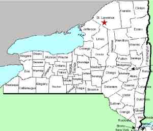
From NY 11 in Gouverneur, drive east
on NY 58 for nine miles. At that point, take a
right on CR24 and drive about 1.4 miles. Park
after crossing the bridge.
|
| County: |
St. Lawrence |
| Town: |
Fowler |
| USGS Map: |
Edwards |
| Waterway: |
Oswegatchie River
West Branch |
| Latitude: |
N 44°
15' 55" |
| Longitude: |
W 75°
20' 33" |
| Drop: |
~12' |
| Type: |
Segmented |
| Region: |
Southeast of Gouverneur |
| Parking: |
Roadside |
| Trail type: |
Dirt |
| Length of hike: |
1 minute |
| Difficulty: |
Easy |
| Accessibility: |
Public |
| Name: |
Official |

|
 The
application to have this waterfall officially named is pending. The
application to have this waterfall officially named is pending. Near the hamlet of Fullerville, there are two sections
of these falls, separated by a small island and are clearly visible from
the bridge. This section of CR 24 is also known locally as the Russell
Turnpike, which has a significant part in the history of this area
and in the War of 1812.
We have information that Fullerville Falls, along with
Fullerville Upper Falls, were once known collectively in the
area as Twin Falls. The name of this waterfall is now
official, having been added to the GNIS data base on November 9,
2017.
There are three other small waterfalls upstream from
these two.
The Oswegatchie River flows into the St. Lawrence River in
Ogdensburg, New York.
Last update: November 14, 2017
|


