| Directions
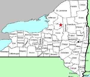
To get here, travel NY 12 to Lyons Falls. Find
the bridge crossing the Black River and continue.
Lowdale Road is just after the paper mill on your left.
Park in the area provided.
|
| County: |
Lewis |
| Town: |
Lyonsdale |
| USGS Map: |
Port Leyden |
| Waterway: |
Moose River |
| Latitude: |
N 43° 37' 8" |
| Longitude: |
W 75° 18' 15" |
| Drop: |
20' |
| Type: |
Slide |
| Region: |
East of Lyons Falls |
| Parking: |
Unpaved lot |
| Trail type: |
Asphalt |
| Length of hike: |
2 minutes |
| Difficulty: |
Easy |
| Accessibility: |
Public |
| Name: |
Common |

|
One of several sections of waterfalls or rapids on the lower
part of the Moose River, this site is directly under the bridge
on the Lowdale Road at Lyonsdale, in the left channel of the river.
This stretch of the river is very popular with the kayak community.
It is our understanding that the entire span of the river here
was originally known as Lyonsdale Falls. Since the whitewater
community has dubbed the right channel "T-Bone", we have
posted pictures of this side separately. The name apparently
comes from the shape of the drop. After sliding under this
bridge, the river comes to an island where the water flow is diverted
at right angles around it, in a "T" shape. The water
going left joins the water flowing out of Lyonsdale Falls
To get to T-Bone, cross the first steel bridge on the Lowdale
Road which takes you to an island. T-Bone is located under
and downstream of the second one-lane bridge, which was closed to
vehicular traffic in 2013.
The Moose River flows into the Black River just a few miles downstream
from this location in Lyons Falls. The Black empties into
Lake Ontario in the Jefferson County community of Dexter.
Last update: January 28, 2016
|


