| Directions
This waterfall is south of the Old Forge area.
We are still researching information on it.
|
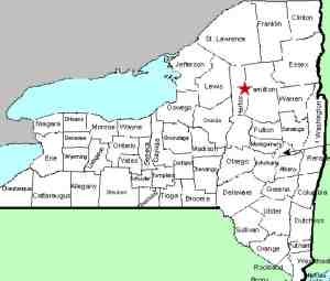
| County: |
Herkimer |
| Town: |
Ohio |
| USGS Map: |
Old Forge |
| Waterway: |
Moose River South Branch |
| Latitude: |
43° 39' 49" |
| Longitude: |
74° 54' 20" |
| Drop: |
NA |
| Type: |
NA |
| Region: |
South of Old Forge
off NY 28 |
| Parking: |
NA |
| Trail type: |
NA |
| Length of hike: |
NA |
| Difficulty: |
NA |
| Accessibility: |
Public |
| Name: |
Official |

|
We have, for some time, been very confused about this waterfall.
Many on-line sources indicate that you access it from campsite
87 at the Limekiln Lake DEC Campground.
We will go on
record as saying, this is not that waterfall! First of
all, Limekiln Falls is an officially named waterfall, listed on
the GNIS. The coordinates of it, according to that data
base are at least eight (8) miles from that campground.
Secondly, those falls are noted as being on Limekiln Creek, the
outlet of Limekiln Lake. The officially named Limekiln
Falls are on the South Branch of the Moose River.
It is
our contention that what many sites indicate to be Limekiln
Falls is actually an unnamed waterfall that we will from this
point on refer to as Limekiln Creek Falls. It is true that
there are many waterfalls that use the same name so if people
want to continue to use Limekiln Falls for that location, that's
okay with us too!If anyone has any information or pictures of this waterfall,
we would be very interested in
hearing from
you.
The south branch of the Moose River joins the middle branch just
northeast of McKeever to become the Moose River. This continues
into the Black River in Lyons Falls which empties into Lake Ontario
near Dexter in Jefferson County.
Last update: June 15, 2021
|


