| Directions
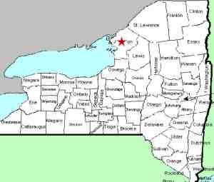
This waterfall is located off the east side of the north-bound
lane of I-81, about 4.2 miles north of the I-781 interchange.
It is just before a median access road.
|
| County: |
Jefferson |
| Town: |
Pamelia |
| USGS Map: |
Brownville |
| Waterway: |
Miller Creek |
| Latitude: |
N 44° 6' 7" |
| Longitude: |
W 75° 54' 14" |
| Drop: |
15' |
| Type: |
Step |
| Region: |
North of Watertown |
| Parking: |
Shoulder of an Interstate |
| Trail type: |
NA |
| Length of hike: |
NA |
| Difficulty: |
Easy |
| Accessibility: |
Private |
| Name: |
Unnamed |

|
This waterfall itself is probably on private property
but can be viewed from the shoulder of I-81. Since this is
an interstate highway, traffic will be passing at a high rate of
speed so please use caution.
Miller Creek Falls is a two-part drop. The upper part is
estimated to be about eight feet in total, with two small drops
followed by a plunge of about six feet. Roughly thirty feet
downstream there is another cascade of about six feet just
before the creek flows through a culvert and under I-81.
It is our understanding that it is flowing well in the spring
but will be down to a "trickle" in the fall.
Miller Creek flows into Perch Lake, which is a wide spot in the
Perch River, at an area known as the Perch River Wildlife Management
Area. This, in turn, flows into the Black River Bay which
is on the eastern end of Lake Ontario.
Last update: November 20, 2015
|


