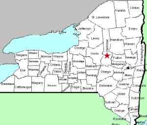
| Directions
From the intersection of NY 169 and NY 29 in Middleville,
proceed east NY 29 for almost exactly one mile. This
waterfall is on the left, just upstream from where the road
crosses the creek.
|
| County: |
Herkimer |
| Town: |
Fairfield |
| USGS Map: |
Middleville |
| Waterway: |
Maltanner Creek |
| Latitude: |
N 43° 08' 15" |
| Longitude: |
W 74° 56' 56" |
| Drop: |
NA |
| Type: |
Step |
| Region: |
Just east of Middleville |
| Parking: |
Roadside |
| Trail type: |
Dirt |
| Length of hike: |
0.1 mile |
| Difficulty: |
Easy |
| Accessibility: |
Public |
| Name: |
Unnamed |

|
 This is an unnamed, roadside accessible waterfall which we have
named for its location. The waterfall is comprised of
two or three steps upstream of the bridge, followed by a slide under
the bridge and completed by a number of gentle steps downstream
of the bridge. This is an unnamed, roadside accessible waterfall which we have
named for its location. The waterfall is comprised of
two or three steps upstream of the bridge, followed by a slide under
the bridge and completed by a number of gentle steps downstream
of the bridge.
The Maltanner Creek flows into the West Canada Creek just downstream
of the Trenton Falls area. This empties into the Mohawk River,
which then flows into the Hudson before reaching the Atlantic Ocean.
Last update: October 7, 2017
|


