| Directions
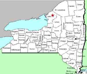
This waterfall is located on private property on the
Keyser Road in the town of LeRay.
|
| County: |
Jefferson |
| Town: |
LeRay |
| USGS Map: |
Black River |
| Waterway: |
Lowell Creek |
| Latitude: |
N 44o 07' 12" |
| Longitude: |
W 75o 51' 51" |
| Drop: |
~20' |
| Type: |
Step |
| Region: |
North of Watertown |
| Parking: |
NA |
| Trail type: |
NA |
| Length of hike: |
NA |
| Difficulty: |
NA |
| Accessibility: |
Private |
| Name: |
Unnamed |

|
 We learned of this waterfall at an author event in Watertown in
November 2015. The property owner came up to our display
and asked if we knew about it. They graciously allowed us
access to their property to take pictures. Since it is on
private property and can not be seen from the road, we are not
posting specific directions to the site. We learned of this waterfall at an author event in Watertown in
November 2015. The property owner came up to our display
and asked if we knew about it. They graciously allowed us
access to their property to take pictures. Since it is on
private property and can not be seen from the road, we are not
posting specific directions to the site.
This is a step
type of falls. We were there in May of the year and the
owners told us that the water was flowing fairly well but was
down compared to earlier in the season. We estimate the
total drop to be around twenty feet in several drops over
horizontal slabs of rock that comprise the creek bed here.
As the pictures indicate, the creek is a lot wider than the flow
at this point. Although this location is not far from the
road, the flow is away from the road so it can't really be seen.
To access the bottom of the falls, you must climb down the rock.
There is no access from the shore. We actually had to walk
through the stream to get most of our pictures. Lowell
Creek flows into Gillette Creek roughly 1700' from this
waterfall. This creek in turn flows into Perch Lake, which is a wide spot in the
Perch River, at an area known as the Perch River Wildlife Management
Area. The Perch flows into the Black River Bay which
is on the eastern end of Lake Ontario.
Last update: May 18, 2016
|


