| Directions
From NY 3 just east of Sackets Harbor, proceed
southeast on the Smithville Road/CR 75. In about
1.6 miles, take a right. You will still be on CR
75. Follow this road for about four miles.
Shortly after passing through the hamlet of Smithville,
you will come to a four-way stop at the Shear Road.
This waterfall is on the left about 500 feet past this
intersection.
|
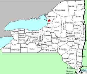
| County: |
Jefferson |
| Town: |
Adams |
| USGS Map: |
Henderson |
| Waterway: |
Little Stony Creek |
| Latitude: |
N 43° 50' 26.40" |
| Longitude: |
W 76° 06' 18.87" |
| Drop: |
25' |
| Type: |
Ribbon cascade |
| Region: |
Just east of Henderson |
| Parking: |
Roadside |
| Trail type: |
Roadside |
| Length of hike: |
Roadside |
| Difficulty: |
Easy |
| Accessibility: |
Probably private |
| Name: |
Unnamed |

|
 Our first trip to this location was in
August 2016, which was at the end of a very dry summer. Consequently, what we found was a cliff rather than a waterfall!
We returned in October following several days of very heavy rain
and had some flow. Our first trip to this location was in
August 2016, which was at the end of a very dry summer. Consequently, what we found was a cliff rather than a waterfall!
We returned in October following several days of very heavy rain
and had some flow.
In the big picture, this might be a seasonal waterfall even
during a normal summer. We are claiming that it is on the
Little Stony Creek. Topographical maps show this five-mile
long waterway
flowing from Crystal Lake to Lake Ontario. Although this
upstream part of the creek isn't labeled, it is the smaller of two
fingers that join just downstream from this location and feed
that lake. Since both of these sections drain swampy areas
above, they may well dry up every summer. This drop is a little over one-half mile from its
source.
We have dubbed this Butterville Falls because it
is in a portion of the town of Henderson known locally as
Butterville. The waterfall is about 200 feet off the
highway and is only about 150 feet from the Adams town line.
This creek flows into Crystal Lake about a mile
downstream. The outlet of this is the Little Stony Creek
that drains into Lake Ontario at Black Pond, a bay just off Lake
Ontario south of Stony Point in the town
of Henderson.
Last update: October 23, 2016
|


