| Directions
In the hamlet of Keene Valley, take Adirondack Street
until you reach "The Garden" parking area.
It is our understanding that there is a fee to park
here.
|
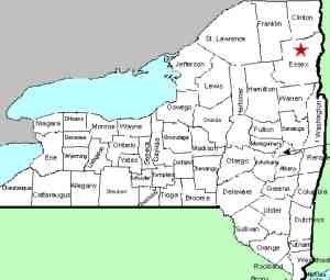
| County: |
Essex |
| Town: |
Keene |
| USGS Map: |
Keene Valley |
| Waterway: |
Johns Brook |
| Latitude: |
N 44° 08' 43" |
| Longitude: |
W 73° 52' 58" |
| Drop: |
20' |
| Type: |
Ribbon cascade |
| Region: |
Off NY 73 west of Keene Valley |
| Parking: |
Unpaved lot |
| Trail type: |
Dirt |
| Length of hike: |
5.0 mile one-way |
| Difficulty: |
Difficult |
| Accessibility: |
Public |
| Name: |
Official |

|
It is our understanding that this is a fairly strenuous hike,
which we have not yet done. Our pictures were provided by
a regular contributor, John Holmes.
This is a very
popular hiking area and the parking lot is often full early on
weekends. There is an alternative parking area at the
Marcy Field lot north of Keene Valley. A shuttle bus
usually runs usually runs on busy weekends. Most hiking
websites warn that it is a long hike and you may return after
the last bus returns so please be aware of that possibility.
The primary trailhead is at the Garden parking area. From
there, the hike is fairly gentle for the first three miles until
you start to descend into Johns Brook Valley. Follow the
signs to Johns Brook Lodge and a spur trail to the waterfall is
1.5 to 2 miles beyond. The side trail leading to the base
of the falls is less than 1/4 mile.
If anyone has any additional information on this site, please
contact
us.
Johns Brook enters the Ausable River East Branch at the hamlet
of Keene Valley. This then joins forces with the west branch
in Ausable Forks. The combined Ausable River empties into
Lake Champlain in the town of Peru.
Last update: May 24, 2016
|


