| Directions
Take the Number Four Road east from Lowville. In
Crystal Dale, take a right on the Erie Canal Road.
Just short of 3 miles, take a left on the McPhilmy Road.
A very short distance up this road, your first intersection
will be the dirt/gravel Beach Mill Road. Take a left.
In about 1.5 miles, there is a fork with a sign indicating
that you want to bear left. In a little over 2 miles,
the road will end at the Beach Mill Pond trailhead.
|
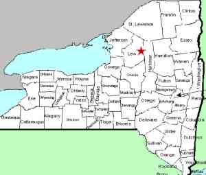
| County: |
Lewis |
| Town: |
Watson |
| USGS Map: |
Number Four |
| Waterway: |
Independence River |
| Latitude: |
N 43° 47' 56" |
| Longitude: |
W 75° 13' 46" |
| Drop: |
~30' |
| Type: |
Curtain cascade |
| Region: |
East of Lowville |
| Parking: |
Unpaved lot |
| Trail type: |
Dirt |
| Length of hike: |
2.5 miles, one-way |
| Difficulty: |
Moderate |
| Accessibility: |
Public |
| Name: |
Common |

|
Gleasmans Falls is the most remote waterfall
in Lewis County that we know of. At the trailhead parking,
signs clearly mark the beginning of the trail. Follow the
yellow markers. This trip is not for the faint of heart.
We would call the majority of this trail moderate in difficulty.
It is clearly marked and well maintained. For the most part
it is fairly level. There are really only a couple of challenges.
The last quarter mile or so does have some significant ups and downs.
Even those aren't bad. The real challenge is that you are
looking at over 2.5 miles in one direction. Sneakers would
be the desired footwear on this one. You won't need water
shoes and even hiking boots aren't necessary. You will want
to pack your granola bars and water bottle. If done during
the right season, you will find an abundance of blueberry and blackberry
bushes and you can forage your way throughout this hike.
About 0.1 mile in, you will cross the Burnt Creek on a wooden
bridge. Just past this, there is a registration kiosk.
The last visitors before us were two days prior. Given the
length of this hike, you won't be overwhelmed with others during
your visit. At a little over a mile in, you will pass by a
beaver pond/swamp. At the end of this there is a small footbridge
over the swamp. Another 3/4 of a mile, give or take, and you
will cross a bridge over the Second Creek, a feeder of the Independence
River. From here you will hike up a hill where you will pass
a large boulder next to a sign indicating that Gleasman Falls is
another 0.1 mile.
There are a couple of points where you can get to the river's
edge and see the falls ahead of you. Continue walking and
another trail, although not clearly marked, can be taken to the
river right at the top of this multi-step waterfall.
The Independence River flows into the Black River just a few
miles downstream from this location in the town of Watson.
The Black empties into Lake ontario in the Jefferson County community
of Dexter.
Note: Most sources refer to this as Gleasman Falls.
As our pictures show, signs on the trail use both Gleasmans Falls
and Gleasman's Falls.
Last update: October 27, 2015
|


