| Directions
In the village of Corinth, turn on River Street.
This is a short street that begins/ends on Main Street/NY9N
and Palmer Street. Look for Curtis Park.
|
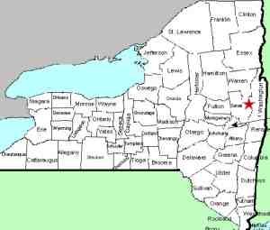
| County: |
Saratoga/Warren |
| Town: |
Moreau/Lake Luzerne |
| USGS Map: |
Corinth |
| Waterway: |
Hudson River |
| Latitude: |
N 43o 14' 48" |
| Longitude: |
W 73o 49' 44" |
| Drop: |
20' |
| Type: |
Dam/slide/cascade |
| Region: |
Village of Corinth |
| Parking: |
Unpaved lot |
| Trail type: |
Roadside |
| Length of hike: |
2 minutes |
| Difficulty: |
Easy |
| Accessibility: |
Public |
| Name: |
Common |

|
This waterfall, as is the case with many on the
Hudson River, is now a hydro-electric facility.
There is a little park here and from that area, you can walk
downstream to view the dam/falls. There is still a waterfall
at the base of the dam. It splits around a large outcrop in
the middle of the channel. on river left, there is a fairly
vertical plunge. on river right, it is a slide. The
dam probably doesn't physically affect the waterfall. Even
without it, the top of the falls would be the same level.
As with any hydro facility, however, the flow is controlled and
there are probably times when there is little to no water flowing.
The downside here is that photo opportunities are limited.
The best angle to get pictures from this side of the river is blocked
by the hydro plant. From where you can see the waterfall,
there is a chain link fence considerably taller than most people
and there is barbed wire at the top of it.
The Hudson River flows into the Atlantic ocean.
Last update: october 12, 2015
|


