| Directions
From the junction of CR 17 and CR 27 in the hamlet of
Degrasse, proceed northeast on CR 27. In about 2.4
miles, there is a bridge crossing the Grass River Middle
Branch. This waterfall is upstream from here.
|
| County: |
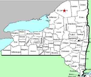
St. Lawrence |
| Town: |
Clare |
| USGS Map: |
West Pierrepont |
| Waterway: |
Grass River Middle Branch |
| Latitude: |
N 44o 21' 53" |
| Longitude: |
W 74o 57' 14" |
| Drop: |
10' |
| Type: |
Slide |
| Region: |
South of Canton |
| Parking: |
NA |
| Trail type: |
NA |
| Length of hike: |
NA |
| Difficulty: |
NA |
| Accessibility: |
Private |
| Name: |
Unnamed |

|
We have not yet been to this
waterfall. It is indicated on topographical maps simply as "Falls".
The Dean Road, which exits CR27 just north of the bridge mentioned
in the direction side-bar dead-ends a little over a mile, as the
crow flies, from this waterfall. There are trails shown in
the area but we have found that it is privately owned. We
do not know if this area is accessible by kayak by paddling
upstream.
Our only photographs of this area were provided by a
contributor. If anyone has any information or pictures of this location, please
contact us.
The middle branch joins forces with the south branch to form
the Grass River about six miles downstream from this waterfall.
The Grass River flows into the St. Lawrence River in Massena, in
St. Lawrence County.
Note: Depending upon which map or sign you are using, this
river is referred to as either Grasse or Grass.
Officially, it is Grass.
Last update: January 10, 2017
|


