| Directions
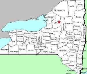
This area is located just east of NY 12 between the communities
of Lyons Falls and Glenfield. Take the Burdick Crossing
Road east to The Lyons Falls Road, CR 39. Take a right
here and then a left on the Fish Creek Road. The Singing
Waters Park will be a short distance down on the left.
|
| County: |
Lewis |
| Town: |
Greig |
| USGS Map: |
Brantingham |
| Waterway: |
Fish Creek |
| Latitude: |
N 43o 39' 46" |
| Longitude: |
W 75o 19' 22" |
| Drop: |
~12' |
| Type: |
Cascade |
| Region: |
Off NY 12 between Lyons Falls and Glenfield |
| Parking: |
Roadside |
| Trail type: |
Dirt |
| Length of hike: |
0.1 mile |
| Difficulty: |
Easy |
| Accessibility: |
Public |
| Name: |
Official |

|
 This area is a very popular
picnic and camping area. This park has been open since 1957.
The picnic area there can accommodate well over 100 picnickers and
overnight camping is permitted in the area. The entire area
has been reforested in stages over the years and is now a very scenic
setting. There are two very nice bridges over the creek to
the picnic area and various promotional brochures for the area indicate
that trout abound in the stream. This area is a very popular
picnic and camping area. This park has been open since 1957.
The picnic area there can accommodate well over 100 picnickers and
overnight camping is permitted in the area. The entire area
has been reforested in stages over the years and is now a very scenic
setting. There are two very nice bridges over the creek to
the picnic area and various promotional brochures for the area indicate
that trout abound in the stream.
The area is dedicated to the memory of Theodore Woolschlager.
He is noted as the first Lewis County forester and is considered
responsible for the planning of the picnic area.
At the February 8, 2018 meeting of the BGN, the decision was
made to enter the name of Singing Waters Falls into the GNIS.
The Fish Creek flows into the Black River just downstream from
Lyons Falls. The Black River joins Lake Ontario just west
of Watertown in Dexter, New York.
Last update: February 24, 2018
|


