| Directions
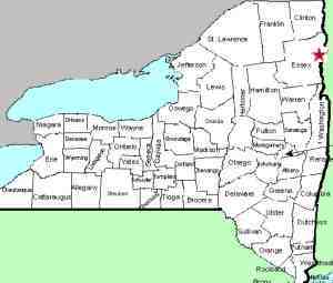
Take NY 22 to the hamlet of Willsboro. There
are two locations where the falls can be viewed.
Gilliland Lane exits north from NY 22 on the east side
of the river. Proceed
to a fishing access area ahead on your left and park.
Mill Lane is on the other side of the Boquet. It
also exits north. You will easily find a parking
area on the edge of the river.
|
| County: |
Essex |
| Town: |
Willsboro |
| USGS Map: |
Willsboro |
| Waterway: |
Boquet River |
| Latitude: |
N 44° 22' 00" |
| Longitude: |
W 73° 23' 31" |
| Drop: |
20' |
| Type: |
Slide |
| Region: |
NY 22 between Keeseville and Westport |
| Parking: |
Unpaved lot |
| Trail type: |
Dirt |
| Length of hike: |
<0.1 mile/1 minute |
| Difficulty: |
Easy |
| Accessibility: |
Public |
| Name: |
Common |

|
 From
the Gilliland Lane side of the river, you will pass the
old high school which has been converted to a senior
living center. Beyond that you will find an anglers
parking area.
Several trails are available to the riverbank where you have an
unobstructed view of the waterfall.
The first four pictures were taken from this side. From
the Gilliland Lane side of the river, you will pass the
old high school which has been converted to a senior
living center. Beyond that you will find an anglers
parking area.
Several trails are available to the riverbank where you have an
unobstructed view of the waterfall.
The first four pictures were taken from this side.
The opposite side of the river gives you a view from a little
further downriver. It is also fairly unobstructed.
Our last two photos and the video provided were taken from here.
The river here is probably over 100 feet wide.
At the top of the falls is a dam which is part of a working hydro-electric
facility. Below that there is a slide of about 75' that drops
about five feet before a drop of two feet over a ledge. The
slide continues for another 30 feet or so and another six foot drop.
From there, there is a level stretch before a series of rapids heading
down to the fishing access area.
The Boquet River flows into Lake Champlain near Willsboro, New
York.
Last update: April 30, 2017
|


