| Directions
Just north of the I-87 exit 30, US 9 and NY 73 intersect.
About 2.3 miles north of here on route 9, you will cross
the river and there is a parking area on the right.
|
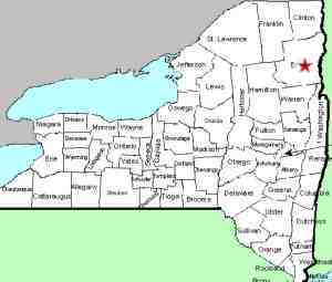
| County: |
Essex |
| Town: |
Elizabethtown |
| USGS Map: |
Elizabethtown |
| Waterway: |
Boquet River |
| Latitude: |
N 44o 07' 31" |
| Longitude: |
W 73o 39' 17" |
| Drop: |
35' |
| Type: |
Ribbon cascade/multiple steps |
| Region: |
US 9 between the intersection of NY 73 and
the hamlet of New Russia |
| Parking: |
Paved parking lot |
| Trail type: |
Dirt |
| Length of hike: |
0.1 mile/2 minutes |
| Difficulty: |
Easy |
| Accessibility: |
Public |
| Name: |
Official |

|
 As you exit your vehicle in the parking
area, you will hear the falls. In the center section of the
parking area, there is a chain link fence. The viewing area
here is near the top of the falls. Portions of this fence
have been broken down and you can get closer to the river, but there
is a better route. As you exit your vehicle in the parking
area, you will hear the falls. In the center section of the
parking area, there is a chain link fence. The viewing area
here is near the top of the falls. Portions of this fence
have been broken down and you can get closer to the river, but there
is a better route.
At the north end of the parking lot, there are some openings
in the wooden guard rails leading to an obvious trail. There
are no railings or retaining devices in this area, so use caution.
At the top of the falls, the river finds its way through an outcropping
of sharp, jagged rocks, forming several drops of about 15 or 20
feet into a pool. The next drop is a single plunge of another
15 feet or so, where the river levels out for a hundred yards or
so. At this point, there is another outcropping of jagged
rocks where there is a slide of another 10' or so. The river
then calmly carries the water away.
According to Russell Dunn, in his book Adirondack Waterfall
Guide the river at this point was at one time the border between
US and Canada. That was changed in 1777. Formerly private
land, it was given to the state in 1982. That was also the
same year that the spelling of the river's name was changed from
Bouquet to Boquet. Obviously derived from French, the locals
pronounce it "bow-ket".
The Boquet River flows into Lake Champlain near Willsboro, New
York.
Last update: May 23, 2016
|


