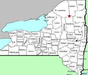
| Directions
At the very southern end of Tupper Lake, Rt 421 meets
NY 30. Traffic signs at this corner will indicate
"Horseshoe Lake" and there is a DEC sign for the "Bog
River Area". In about 0.6 miles, this road will
take a bend to the left and you will cross a small
bridge. You are passing Bog River Falls here.
At 1.6 miles, take a sharp left and go up a steep hill.
At 3.0 miles, there is a yellow metal gate and a sign
noting "Winding Falls".
|
| County: |
St. Lawrence |
| Town: |
Piercefield |
| USGS Map: |
Piercefield |
| Waterway: |
Bog River |
| Latitude: |
N 44o 06'
58" |
| Longitude: |
W 74o 34'
54" |
| Drop: |
35' |
| Type: |
Cascade |
| Region: |
NY 30 between Tupper Lake and Long Lake |
| Parking: |
Roadside |
| Trail type: |
Dirt |
| Length of hike: |
2.5 miles, one-way |
| Difficulty: |
Difficult |
| Accessibility: |
Public |
| Name: |
Common |

|
All of the information on this page was sent in by a
contributor. Our thanks to Bill Hill for this. All
information we have found on-line for this location notes that
this is not a hike that should be undertaken by a rookie!
The trail is not clearly defined in some spots. In
addition, there are beaver ponds to get past and a compass and
knowledge of its use is probably a necessity.
This is a relatively lesser known waterfall. We have
found references to it as Winding Falls but there are two small
stone markers, similar to cemetery foot-stones, inscribed to
"Dad" and "Pa". Because of these, it is also known locally
as "Pa's Falls".
There is one website blog detailing this hike that notes that
the DEC might be considering updating the trail to this
waterfall. We have not been able to substantiate that
claim.
The Bog River flows into Tupper Lake, which feeds the Raquette
River. The Raquette flows into the St. Lawrence River in Massena,
New York.
Last update: August 17, 2019
|


