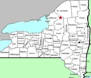
| Directions
The Jerden Falls Road is located off the east side of NY
812 just north of the hamlet of Indian River. Head
north on it. Actually, if you are coming from the
north, a left on the Dutton Road and then a left on the
Jerden Falls Road will save you a few miles. Check your
odometer as you cross the Oswegatchie. In about 1.5
miles, there is a dirt road to the right. Park on
this corner.
|
| County: |
Lewis |
| Town: |
Croghan |
| USGS Map: |
Remington Corners |
| Waterway: |
Blanchard Creek |
| Latitude: |
N 44o 02'
04" |
| Longitude: |
W 75o 18'
47" |
| Drop: |
~12' |
| Type: |
Ribbon Cascade |
| Region: |
South of Harrisville |
| Parking: |
Roadside |
| Trail type: |
Dirt |
| Length of hike: |
0.1 mile |
| Difficulty: |
Easy |
| Accessibility: |
Public |
| Name: |
Unnamed |

|
 From
the corner where you parked, walk a bit further up the road you
had been on and look to the left side. You will easily see
the waterfall. This is all NYSDEC land that is easy to
walk, so access will not be an issue, either physically or
legally. From
the corner where you parked, walk a bit further up the road you
had been on and look to the left side. You will easily see
the waterfall. This is all NYSDEC land that is easy to
walk, so access will not be an issue, either physically or
legally.
Although only about twelve feet tall, this is a very pleasant
roadside gem. It is only a couple of miles from the better
known Jerden Falls and is worth the trip if you are in the area.
There are two Blanchard Creeks in Lewis County. One
originates just west of the Oswegatchie River's West Branch,
roughly 3.2 miles from where this Blanchard Creek enters the
Oswegatchie, a little over one mile from this waterfall. The
West Branch joins the main channel near Talcville in the town of
Edwards in St. Lawrence County. This flows to the St. Lawrence
River in Ogdensburg.
Last update: June 30, 2017
|


