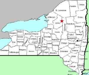
| Directions
In the village of Lowville, less than 1/4 mile south
of the intersection of NY 12 and NY 26, NY 12 crosses the Mill
Creek. Just south of here, take River Street east.
This becomes the Number Four Road. As you come through
Watson, Millers Meat Market will be on your left.
Just past this, you will take a left-hand turn to stay on
the Number Four Road! Continue another 15.3 miles
where you should take a right on the Stillwater Road.
In about two miles from here, take a left on the Moshier
Road. At 0.6 mile, there is a parking area on the
right.
|
| County: |
Herkimer |
| Town: |
Webb |
| USGS Map: |
Stillwater |
| Waterway: |
Beaver River |
| Latitude: |
43o 53' 15" |
| Longitude: |
75o
06' 35" |
| Drop: |
70' |
| Type: |
Ribbon cascade into slide |
| Region: |
Northeast of Lowville |
| Parking: |
Dirt lot |
| Trail type: |
Unpaved road |
| Length of hike: |
5.5 miles, round-trip |
| Difficulty: |
Moderate |
| Accessibility: |
Public |
| Name: |
Common |

|
Just beyond the parking area, there is a gate. Signs indicate
that the canoe access is 2.5 miles from this point. This dirt
road is in fairly good shape. We have actually driven on many
in our waterfall travels that were much less maintained. Signage
indicates that unauthorized motor vehicles are prohibited.
Be aware before making this trip that a bicycle would be a good
option! A mountain bike would make this a lot quicker trek! As you
hike along this road, you will be following an elevated penstock
on your left. At 0.9 mile in, the penstock becomes buried.
At about two miles, you will come to a fork in the road. Continue
to the right and follow the signs. You will come to the canoe
access on Moshier Reservoir. Continue to the left past this
and you will come to the top of the Moshier Dam. Turn
left and walk down the hill. Moshier Falls will be on your
right. You will be right next to the falls and have an excellent
view. As our pictures show however, foliage, mounds of earth,
rock and other obstructions limit the pictures you can get.
The other side of the river would undoubtedly provide better views
for that.
The hydro-electric dam built at this location is above the top
of the falls. During the majority of the year, the waterfall
is only present on river left where a deep gorge has formed.
The first drop is a cascade of about 15 feet. From there,
it drops slightly through a channel into another drop, also about
15 feet. Then there is a long, natural waterslide that drops
about 30 feet over a 150' or so of the river. The channel
then cuts left through another slide of about 10 feet. Close
to 80% of the width of the river is a huge granite outcropping.
During heavy spring run-off there is probably a good chance that
this area looks quite a bit different. Part of this is probably
covered.
Our thanks to Vic Clarise of Brookfield Power. There was
a maintenance crew there on the day of our visit. Vic was
the supervisor of the crew and told us that because of the maintenance,
the public shouldn't be there. However, because we had already
walked 1.75 miles to that point, he felt sorry for us and, not only
allowed us to continue, but guided us to where we needed to go.
As a point of interest, USGS topographical maps show four other
waterfalls just downstream of this area. other information
we have obtained also indicates that there are other falls.
Access to them, however, is evidently only possible by canoe or
kayak on the river because that area is posted along the penstock
region.
The Beaver River flows into the Black River, which empties into
Lake Ontario at the Black River Bay, just southwest of the village
of Dexter.
Last update: July 28, 2015
|


