| Directions
Take the Belfort Road from the village
of Croghan to the hamlet of Belfort. Then follow
the Long Pond Road and turn left when you come to the
Bisha Road. Go to the end of this road and you
will find a parking lot with a NYS DEC sign noting that
it is the West Branch Oswegatchie Fishing Access Site,
lot 11960.
|
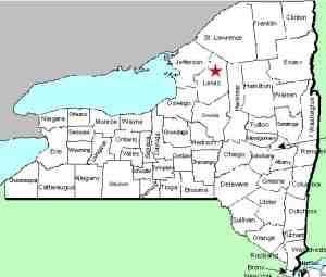
| County: |
Lewis |
| Town: |
Croghan |
| USGS
Map: |
Remington
Corners |
| Waterway: |
Oswegatchie
River West Branch |
| Latitude: |
N
44° 00' 12" |
| Longitude: |
W
75° 16' 16" |
| Drop: |
~50' |
| Type: |
Ribbon
cascade |
| Region: |
Northeast
of Croghan |
| Parking: |
Unpaved
lot |
| Trail
type: |
Dirt |
| Length
of hike: |
1
mile, one-way |
| Difficulty: |
Easy |
| Accessibility: |
Private,
access by agreement |
| Name: |
Common |

|
This is actually a very
impressive waterfall and it is not even indicated on USGS topographical
maps. It is also necessary to note that this is one of several
High Falls in the area. There are two others in Lewis County,
one just a few miles away on the Beaver River, also in the town
of Croghan. The other is on the
Deer River in Copenhagen,
due west of this one on the western edge of the county. There
is another High Falls on the Oswegatchie
River. This one is on the main channel in the St. Lawrence
County town of Fine in a fairly remote section of the Adirondacks.
In addition, there are at least four other falls named High Falls
throughout northern New York. This waterfall is the only High
Falls that we know of that is technically unnamed. All of
the others are officially named High Falls.
Note that the area you will be hiking is private land and posted,
but it is a Conservation Easement Public Recreation Area.
Public access is allowed along the river. Go past the gate
past the parking lot into an area known as Long Level and bear left.
Follow the yellow Public Fishing Foot Path signs that mark the trail.
At about 0.7 of a mile down the trail you will pass the
Shingle Mill Falls.
Continue a little less than a quarter mile downstream and you will
come to High Falls.
This waterfall plunges about 50' into a pool. The river
then takes another drop and then a series of rapids as it continues
its route downstream. If we were promoting retail shopping,
we would call this one a "best buy"! It is a bit
of a walk in. The hike will take you close to 30 minutes over
almost a mile of moderate to above hiking, but it is well worth
the trip. The upper part of this waterfall is a free-fall
that is very pretty. As you stand on the top of the ridge
across from it, you will feel the spray, even though you are a couple
of hundred feet away. You are outside of the Adirondack Park
limits at this point, so you aren't even in the wilds of northern
New York but beauty knows no boundaries. You are still in
a fairly remote setting. There are no railings or fences so
take care. You are on the edge of a fairly deep drop.
This is a site that is there to be enjoyed. Remember to carry out
whatever you carry in.
The West Branch of the Oswegatchie joins the main channel a few
miles downstream, just west of the hamlet of Talcville in the town
of Edwards. This then flows to the St. Lawrence River in Ogdensburg.
Last update: April 28, 2016
|


