| Directions
From NY 30 in Wells, at the southern end of Lake Algonquin,
take Algonquin Drive west. You will cross the Sacandaga River
and in about 3/4 mile, take a left on West River Road/CR
5.
About 2.4 up this road, you will come to a "Y" where you
should bear left. In
another mile, you will come to the Jimmy Creek.
Park on the roadside.
|
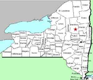
| County: |
Hamilton |
| Town: |
Wells |
| USGS Map: |
Three Ponds Mt |
| Waterway: |
Jimmy Creek |
| Latitude: |
N 43° 22' 14.2" |
| Longitude: |
W 74° 21' 09.3" |
| Drop: |
15' |
| Type: |
Ribbon Slide |
| Region: |
Off NY 30 southwest of Wells |
| Parking: |
Roadside |
| Trail type: |
No trail ... walk up the creek |
| Length of hike: |
3/8 mile |
| Difficulty: |
Moderate |
| Accessibility: |
Public |
| Name: |
Common |

|
Please note that Algonquin Drive actually forms a loop around
most of this lake. If you are coming from the north, there
is another point at which you can get onto Algonquin Drive/CR 5.
From this direction, you will be turning right on the West River
Road.
You will encounter this waterfall on your hike to the West Jimmy
Creek Falls. There are trails on either side, but those
properties appear to be posted. This is a "rock-hop"
up the creek to reach the waterfall. You would be advised to have boots
or water shoes but it will be worth the trip.
Since we
were there in late August 2015, which was a particularly dry
summer, the flow was very low and quite unimpressive! We
plan to return earlier next summer to see this with more water. This Jimmy Creek flows into the west branch of the Sacandaga
River which joins the main channel less than three miles downstream
from here. The Sacandaga River flows through a number of lakes
as it makes its way to the Hudson River whose final destination
is the Atlantic Ocean.
Note: There are two Jimmy Creeks in the town of Wells.
The other one enters the east branch of the Sacandaga River about
eight miles from where this one enters the west branch, but they
are totally independent of each other. Due to their proximity
to each other, this one is typically referred to as the West Jimmy
Creek and the other the East Jimmy Creek. That is a logical
but unofficial distinction. Topographical maps simply label
them both Jimmy Creek.
Last update: September 21, 2015
|


