| Directions
From Gloversville, go northeast on NY30.
Just past the village of Mayfield, turn left on the Jackson
Summit Road East. The second left should be the Jackson
Summit Road West. In a little over 0.3 mile, there
will be a dirt road on the right. This becomes a trail
in about 500'.
|
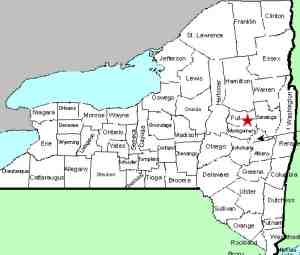
| County: |
Fulton |
| Town: |
Mayfield |
| USGS Map: |
Jackson Summit |
| Waterway: |
Unnamed stream |
| Latitude: |
N 43°
08' 03" |
| Longitude: |
W 74°
17' 43" |
| Drop: |
NA |
| Type: |
NA |
| Region: |
Northeast
of Gloversville |
| Parking: |
NA |
| Trail type: |
NA |
| Length of
hike: |
NA |
| Difficulty: |
NA |
| Accessibility: |
NA |
| Name: |
Official |

|
We have not
yet been to this waterfall, but it is listed on the USGS GNIS.
From the point at which the trail starts, walk about 400'.
The trail will then split. Take the left branch and proceed
about 200 yards when you should reach the creek. From here,
proceed another 100 yards or so where the trail may split again.
The falls should be upstream a short distance on your left.
This is somewhat of an unusual situation. Many waterfalls
are unnamed. This one is officially named, but is on a waterway
that doesn't have any kind of name indicated.
If anyone has any information on this waterfall, we would like
to hear from you.
This unnamed waterway flows into another unnamed waterway that
appears to be the outlet of the Jackson Summit Reservoir.
This empties into the Great Sacandaga Lake, which is part of the
Sacandaga River. This flows into the Hudson before reaching
the Atlantic Ocean.
Note: We have found one reference on-line for Buttermilk
Falls near Stratford NY. This reference didn't locate it specifically
and gave no details. Stratford and Mayfield are both in Fulton
County, about 20 miles apart. Since this was a website promoting
Stratford, we have come to the conclusion that it was referring
to this Buttermilk Falls.
Last update: October 12, 2016
|


