| Directions
From the junction of NY 8 and NY 30 north of Wells, go
east on Route 8 for about 2.5 miles. There is a pull-off
on the right and directly across the road there is a
seasonal dirt road. Follow this for about 0.2 miles
where you will cross a bridge. Park on the
roadside immediately across the river.
|
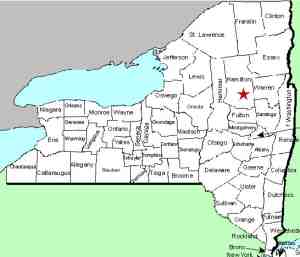
| County: |
Hamilton |
| Town: |
Wells |
| USGS Map: |
Harrisburg |
| Waterway: |
Sacandaga River East Branch |
| Latitude: |
N 43o 28' 22" |
| Longitude: |
W 74o 13' 29" |
| Drop: |
6' |
| Type: |
Cascade |
| Region: |
NY 8 between Wells and the Hamilton/Warren
County line |
| Parking: |
Roadside |
| Trail type: |
Dirt |
| Length of hike: |
0.1 mile |
| Difficulty: |
Easy |
| Accessibility: |
Public |
| Name: |
Common |

|
 There is a logging road to the left after the bridge. Follow this
for no more than a hundred yards. Signs on the right
indicate that this is a forest preserve, wilderness area.
Directly across the road from this is a large tree with paths on
both sides leading to one path into the woods. Follow this
to the river edge and the waterfall. There is a logging road to the left after the bridge. Follow this
for no more than a hundred yards. Signs on the right
indicate that this is a forest preserve, wilderness area.
Directly across the road from this is a large tree with paths on
both sides leading to one path into the woods. Follow this
to the river edge and the waterfall.
This is a very short and easy hike. If you stood on the
bridge that you crossed and looked downstream, you probably
wouldn't be able to tell this is a waterfall because you are
looking over the crest. Standing downstream of the
waterfall, however, you can see the bridge.
This one is somewhere between a slide and a step type falls.
The bed under it has heaved over time and large sheets of rock
are tipped on an angle. As with many Adirondack
waterfalls, this one has a completely different personality in
the spring compared to later in the year.
The east branch of the Sacandaga River joins the main branch
about 2.2 miles downstream from that point. The Sacandaga
River flows through a number of lakes as it makes its way to the
Hudson River whose final destination is the Atlantic Ocean.
Last update: August 26, 2017
|


