| Directions
On NY 3 between Tupper Lake and Saranac
Lake, just east of Panther Mountain and just south of
Upper Saranac Lake, the Coreys Road will exit to the
south. Follow this for about 3 miles. About
0.2 mile after crossing Stoney Creek there is a parking
lot. The trailhead is at the back of the parking
lot, behind the registration kiosk.
|
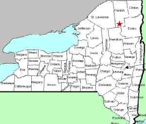
| County: |
Franklin |
| Town: |
Harrietstown |
| USGS Map: |
Tupper Lake |
| Waterway: |
Raquette River |
| Latitude: |
N 44°
08' 29" |
| Longitude: |
W 74°
19' 46" |
| Drop: |
8' |
| Type: |
Curtain cascade |
| Region: |
Between Tupper
Lake and Saranac Lake |
| Parking: |
Unpaved lot |
| Trail type: |
Dirt |
| Length of
hike: |
4.8 miles,
one-way |
| Difficulty: |
Moderate,
long |
| Accessibility: |
Public |
| Name: |
Official |

|
This is the third waterfall
you will come to along this stretch of the Raquette. As we
mentioned on our page for Raquette Falls,
due to the length of the hike, it would stand to reason that you
will visit all three of these on the same hike. Please refer
to our page for Lower Falls
for information common to all three.
Continue along the trail that skirts the river for another 1/2
mile beyond Raquette Falls.
The stretch between these two waterfalls is for the most part one
continuous stretch of rapids with the exception of about 150 to
200 feet of flat water mid-way through the stretch.
Upper Falls is probably the prettiest and nicest drop of these
three falls. The hike between Raquette and Upper is much like
the entire hike from the parking lot. We would classify this
as moderate, with the exception of the last few hundred feet.
The trail deteriorates and there are several up and downs over rocks.
It's not mountain goat country, but it is a little trickier than
the rest of the trail. When you reach the waterfall, you can
descend to the river level. It is somewhat of a scramble but
well worth the effort.
The Raquette River empties into the St. Lawrence River in Massena,
New York.
Last update: August 25, 2016
|


