| Directions
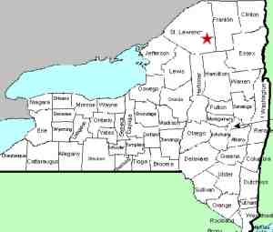
This waterfall is located off the east
side of NY 56, 2.4 miles from where it intersects NY 3 at
Sevey Corners. Just after crossing a small stream,
there is a dirt road on the right. There is a sign
on a tree that sits back from the road that identifies it
as DEC land.
|
| County: |
St. Lawrence |
| Town: |
Colton |
| USGS Map: |
Childwold |
| Waterway: |
Raquette River |
| Latitude: |
N 44° 19'
31" |
| Longitude: |
W 74°
43' 00" |
| Drop: |
20' |
| Type: |
Recangular
Cascade |
| Region: |
NY 56 between
Tupper Lake and Colton |
| Parking: |
Unpaved lot |
| Trail type: |
Dirt/grass
|
| Length of hike: |
1 minute |
| Difficulty: |
Easy |
| Accessibility: |
Public/state land |
| Name: |
Official |

|
 To find this
waterfall, it is essential to use your odometer. As mentioned
in the directions side-bar, there is a DEC sign, but it does sit
back from the road and is easily missed. Also, it doesn't
mention Jamestown Falls. Proceed down this road about 0.3
mile and you will come to the river's edge. There is a
parking area and a boat launch. The falls will
be on your right, a few hundred yards upstream. To find this
waterfall, it is essential to use your odometer. As mentioned
in the directions side-bar, there is a DEC sign, but it does sit
back from the road and is easily missed. Also, it doesn't
mention Jamestown Falls. Proceed down this road about 0.3
mile and you will come to the river's edge. There is a
parking area and a boat launch. The falls will
be on your right, a few hundred yards upstream. Please note that the access road is on public land, but much
of the property in this area is private and posted. To get
closer to the waterfall, you will have to canoe up the river.
The good news is that access is quick and easy here.
On our June 2017 trip here, we found construction equipment
parked and some improvements being made. The road and
parking area have a new dirt surface. Pressure treated
lumber surrounds the parking area and boat launch. We
contacted DEC and were told that "we are doing some extensive
work at the Jamestown Falls site that will include an upgraded
access road, parking lot, accessible privy and campsite."
This is good news for the camping, boating and waterfalling
public!
The Raquette River empties into the St. Lawrence River in
Massena, New York.
Last update: June 1, 2017
|


