| Directions
From NY 28 in the hamlet of Inlet, across from the
west end of Sixth Lake, the Limekiln Road will take you
south. In 1.8 miles, you will find the Limekiln
Lake DEC Campground. There will be a day-use fee
to enter.
|
| County: |
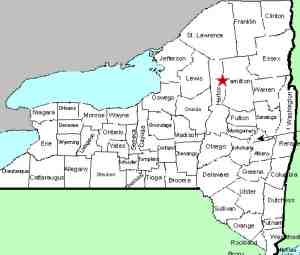
Herkimer |
| Town: |
Ohio |
| USGS Map: |
Old Forge |
| Waterway: |
Limekiln Creek |
| Latitude: |
43° 42' 41" |
| Longitude: |
74° 50' 33" |
| Drop: |
NA |
| Type: |
Slide |
| Region: |
Off NY 28 south of the hamlet of Inlet |
| Parking: |
Campground |
| Trail type: |
Dirt |
| Length of hike: |
NA |
| Difficulty: |
Moderate |
| Accessibility: |
Public |
| Name: |
Unnamed |

|
For some time, we have had this waterfall listed as Limekiln
Falls. We still have a lot of confusion surrounding this,
but we are now inclined to believe that there are two Limekiln
Falls. Limekiln Falls is an officially named waterfall,
listed on the GNIS data base. It appears to be about eight
miles south west of the Limekiln Lake Campground.
In an effort to lessen confusion on this issue, we are now
referring to this location as Limekiln Creek Falls. The
majority of on-line sources noting this title are actually
pointing at this site.
The trail starts at campsite 87. From there, walk
across a large open field to a registration box where a
self-guided nature tour begins. This would imply that all
the info you will need to get to the waterfall will be given
there. This location is actually a series of waterfalls.
Some on-line sources refer to it as rapids. A 15'
wide section of the river drops for about 1/2 mile in length.
If anyone has any information or pictures of these waterfalls,
we would be very interested in
hearing from
you.
Limekiln Creek flows into the south branch of the Moose River.
This later joins the middle branch just
northeast of McKeever to become the Moose River. The Moose continues
into the Black River in Lyons Falls which empties into Lake Ontario
near Dexter in Jefferson County.
Last update: June 15, 2021
|


