| Directions
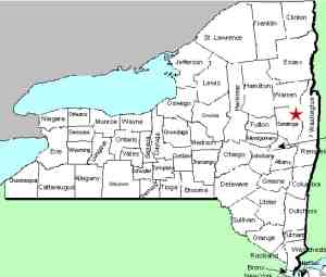
From Exit 18 on I-87, go east into Glens
Falls. Follow this street until reaching US 9 where
you should take a right. Within a few blocks you will
cross the Hudson River where the falls will be on the right.
Park after crossing the bridge. There are many alternative
routes.
|
| County: |
Warren/Saratoga |
| Town: |
Glens Falls/Moreau |
| USGS Map: |
Glens Falls |
| Waterway: |
Hudson River |
| Latitude: |
N 43o 18' 18" |
| Longitude: |
W 73o 38' 34" |
| Drop: |
50' |
| Type: |
Power dam |
| Region: |
on US 9 at the border of Glens Falls and
South Glens Falls |
| Parking: |
Streetside |
| Trail type: |
Asphalt/concrete |
| Length of hike: |
0.1 mile |
| Difficulty: |
Easy |
| Accessibility: |
Public |
| Name: |
Common |

|
There is a significant power dam facility at the
site of Glens Falls. originally known as Great Falls, the
waterfall still exists in concept at the base of the dam.
We have taken pictures twice at this facility. on our first
trip in 2010, there was construction, so views of the dam and falls
was limited. There was water flowing at the time. on
our return in 2013, the construction had ended and the view was
clearer, but there was very little water flowing. The flow
here is controlled by the dam, so there are times when the water
is shut down and not flowing.
Despite the size of this drop and the fact that the community
is named after the falls, this waterfall is not listed on the USGS
GNIS.
There is much folklore about this area. According to a
local account, Coopers Cave is located under these falls.
This is the area from James Fenimore Cooper's book "The Last
of the Mohicans".
The last image in this display is from the postcard collection
of Scott Ensminger of
falzguy.com.
The Hudson River flows into the Atlantic ocean in New York City.
Last update: october 19, 2015
|


