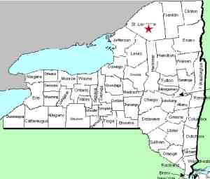
| Directions
The north end of the Tooley Pond Road is less than 1000'
from the junction of CR 17 and CR 27 in the hamlet of Degrasse.
Proceed northeast on CR 27 and take a right. In about
two miles, take a right on the Lake George Road. There
is a bridge a short distance up this road and the waterfall
will be in view upstream.
|
| County: |
St. Lawrence |
| Town: |
Clare |
| USGS Map: |
Degrasse |
| Waterway: |
Grass River South Branch |
| Latitude: |
N 44o 20' 10" |
| Longitude: |
W 75o 02' 38" |
| Drop: |
5' |
| Type: |
Curtain cascade |
| Region: |
Southeast of Canton |
| Parking: |
Roadside |
| Trail type: |
NA |
| Length of hike: |
NA |
| Difficulty: |
Easy |
| Accessibility: |
Public |
| Name: |
Unnamed |

|
Six of the eight well-known
waterfalls on the South Branch of the Grass River are officially
named waterfalls. The other two are commonly named.
We are referring to this unnamed waterfall as Sinclair Upper Falls
because it is just upstream from Sinclair Falls and can be seen
from the bridge next to the trailhead for it.
The majority of the land between the Tooley Pond Road and
this waterfall is state DEC owned. A few feet of land
along the shore is actually owned by National Grid, the power
utility that serves this area. We have not yet determined
if there is a trail leading
to it. We assume there would not be an issue hiking from
the road to this waterfall. Our question is whether or not
it us physically
passable. Without a trail, a bushwhack would be necessary.
Having said that, topographical maps show the distance to be
less than 500 feet with a vertical change of only about ten
feet. The bushwhack should not be overly taxing.
This is on our to do list for the spring of 2017.
The Grass River flows into the St. Lawrence River in Massena,
in St. Lawrence County.
Note: Depending upon which map or sign you are using, this
river is referred to as either Grasse or Grass.
Officially, it is Grass.
Last update: September 28, 2015
|


