| Directions
From the junction of NY 8 and NY 30 north of Wells, go
east on Route 8 for about 1.2 miles. There are parking areas
on both sides of the highway near where a creek goes under
the road through a sluice-pipe.
|
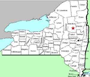
| County: |
Hamilton |
| Town: |
Wells |
| USGS Map: |
Harrisburg |
| Waterway: |
Jimmy Creek |
| Latitude: |
N 43o 27' 10" |
| Longitude: |
W 74o 14' 00" |
| Drop: |
20' |
| Type: |
Ribbon cascade |
| Region: |
NY 8 between Wells and the Hamilton/Warren
County line |
| Parking: |
Roadside |
| Trail type: |
Dirt |
| Length of hike: |
0.1 mile |
| Difficulty: |
Easy |
| Accessibility: |
Public |
| Name: |
Common |

|
 Follow the trail leading up the Jimmy Creek. It
is only about 1/10 of a mile to this waterfall but you will
actually pass the
East Jimmy Creek Lower Falls on your hike.
As noted in that account, better views of the Lower Falls will
be from the trail on your left as you face upstream from the
highway. For Jimmy Creek Falls, however, you will want to
hike up the trail on your right. Follow the trail leading up the Jimmy Creek. It
is only about 1/10 of a mile to this waterfall but you will
actually pass the
East Jimmy Creek Lower Falls on your hike.
As noted in that account, better views of the Lower Falls will
be from the trail on your left as you face upstream from the
highway. For Jimmy Creek Falls, however, you will want to
hike up the trail on your right.
This is two-part waterfall. The upper part is a ribbon
cascade that drops about ten feet into a pool that is about ten
feet across. The second drop is probably ten to twelve
feet in a slide after the rocks in the creek bed.
This Jimmy Creek flows into the east branch of the Sacandaga
River which joins the main branch about one mile downstream from
that point. The Sacandaga River flows through a number of
lakes as it makes its way to the Hudson River whose final destination
is the Atlantic Ocean.
Note: There are two Jimmy Creeks in the town of Wells.
The other one enters the west branch of the Sacandaga River about
eight miles from where this one enters the east branch, but they
are totally independent of each other. Due to their proximity
to each other, this one is typically referred to as the East Jimmy
Creek and the other the West Jimmy Creek. That is a logical
but unofficial distinction. Topographical maps simply label
them both Jimmy Creek.
Last update: August 13, 2021
|


