| Directions
From NYSR 12 in the hamlet of Depauville, turn onto Caroline
Street/CR 179. Within a tenth of a mile, you will
see a mill pond with a fountain on your left. You
will cross a bridge which goes over the outlet of this pond.
The waterfall is just a few feet downstream and can easily
be seen from the walkway over the bridge.
|
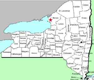
| County: |
Jefferson |
| Town: |
Clayton |
| USGS Map: |
Clayton |
| Waterway: |
Chaumont River |
| Latitude: |
N 44o 08' 22" |
| Longitude: |
W 76o 04' 03" |
| Drop: |
~ 25' |
| Type |
Curtain |
| Region: |
In the hamlet of Depauville |
| Parking: |
Roadside |
| Trail type: |
Roadside |
| Length of hike: |
Roadside |
| Difficulty: |
Easy |
| Accessibility: |
Private |
| Name: |
Official |

|
You can see over the crest of the waterfall from the bridge.
In fact, there is a building at this point which appears to be an
old mill of some kind. This building is actually on a small
island and the falls drop on both sides of it. We weren't
able to get pictures of channel left so we will return to attempt
that later.
Although not posted, the property below this waterfall is private.
We have an acquaintance who knows the owner and they secured permission
to access the property where we got some very nice photos of the
main drop from below.
Catfish Falls is located on the Chaumont River in the hamlet
of Depauville. In fact, when the community of Depauville was
first settled around 1816, it was called Catfish Falls.
We are pleased to announce that we received an email on May
25, 2017, notifying us that our application had been approved by
the US Board on Geographic Names, and the name of this waterfall
has been added to the Geographic Names Information System
(GNIS).
The Chaumont River empties into Lake ontario in the village of
Chaumont, just west of Watertown in Jefferson County.
Last update: May 25, 2017
|


