| Directions
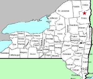
The High Falls Gorge facility is located at 4761 State
Highway 86 in Wilmington, on the highway between the villages
of Wilmington and Lake Placid. It is a very well promoted,
highly commercialized site. You won't be able to miss
it!
|
| County: |
Essex |
| Town: |
Wilmington |
| USGS Map: |
Lake Placid |
| Waterway: |
Ausable River, West Branch |
| Latitude: |
N 44o 20' 56" |
| Longitude: |
W 73o 52' 27" |
| Type: |
Multiple ribbon falls |
| Drop: |
80' |
| Region: |
Between Lake Placid and Wilmington |
| Parking: |
Paved lot |
| Trail type: |
Dirt |
| Length of hike: |
30 minutes |
| Difficulty: |
Easy to moderate |
| Accessibility: |
Business |
| Name: |
Official |

|
These falls are located in a very popular
tourist attraction area known as the High Falls Gorge. At
first, one might think that it
is somewhat ironic that, although it is called High Falls Gorge,
and it is comprised of four waterfalls, none of them are named High
Falls!
Technically, that is not the case.
The USGS GNIS lists this area as High Falls. Officially,
this is considered one waterfall ... High Falls. Older
topographical maps show this. These falls are basically four steps through this gorge.
They literally flow one into the next. The reason for four
names is probably commercial. It sounds more impressive to
pay to see four waterfalls rather than just one!
When you arrive, you must enter through the gift shop area and
pay an entrance fee to access the gorge itself. Because of
this, access is limited to business hours which vary depending upon
time of year and day of the week. The adult admission in 2013
was $10.95. To the hiker/waterfall lover, this price may appear
to be a bit steep. What you get is a 1/2 mile round-trip over
well maintained trails, stairs and bridges. There are several
informational signs describing the local geology. It is one
of only a few Adirondack locations where you will have to pay to
see the waterfalls. The fee, however, is worth it, because
you can't physically see the falls if the facility is closed and
without the walkways and paths, accessing this site would be dangerous
and perhaps impossible.
We had previously posted on this website that only one of the
pamphlets we picked up when we were there in 2011 identified the
falls by name. That trail map indicated three falls; Main,
Mini and Climax. Promotional information found elsewhere noted
three falls, but they are Main, Rainbow and Climax.
When we returned in 2013, new brochures were available and they
now identify four waterfalls.
Coming downstream you first encounter the Main Falls, a 35' drop.
This falls almost immediately into the 5' Mini Falls. After
a short pool is Rainbow Falls, which falls 20'. This can be
confusing because there are two other Rainbow Falls on the Ausable
River. One of them is on the East Branch and the other further
downstream after the two branches converge. Just below Rainbow
is the final drop, Climax Falls. This is another drop of
20' or so. Please note that these measurements are estimates
because the promotional material gained there do not provide this
information.
The Ausable River West Branch joins forces with the East Branch
in Ausable Forks. The combined Ausable River empties into
Lake Champlain in the town of Peru.
Note: This area has also been referred to as the Ausable
River Falls.
Last update: July 27, 2015
|


