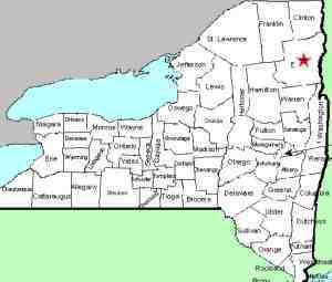
| Directions
Take NY 9N north from the village of Elizabethtown.
After passing the end of Water Street/CR 10A, but before
coming to Lord Road, there is a pull-off on the right.
Park there.
|
| County: |
Essex |
| Town: |
Elizabethtown |
| USGS Map: |
Elizabethtown |
| Waterway: |
The Branch |
| Latitude: |
N 44o 13'
16" |
| Longitude: |
W 73o 36' 49" |
| Drop: |
20' |
| Type: |
Ribbon block |
| Region: |
West end of the
village of Elizabethtown |
| Parking: |
Roadside |
| Trail type: |
Dirt |
| Length of hike: |
120 yards |
| Difficulty: |
Easy |
| Accessibility: |
Public |
| Name: |
Common |

|
Rices Falls is a two-part drop. From the parking area, the
upper section
is less than 100 feet north. The riverbank here is smooth rock and
rather steep, so if it is, or has been raining, care needs to be
taken.
The main drop is a bit downstream.
The easiest access is down the road, a little over a hundred
yards from the parking area. The trailhead is far from
obvious, but there is a spot where a worn path can be found.
A short distance in, there is an overlook, enclosed by mortared
stone. This gives you a good view of this stretch but
downriver views or pictures are not readily available. We
went to the drone for these.
It is not uncommon for more
than one waterway to have the same name. The Branch is
somewhat of an unusual name but there are two of them in
Northern New York. In fact, they are both in Essex County.
The larger The Branch is a bit south of here. It
starts at Elk Lake in the town of North Hudson, flows due south
for about five miles and then takes a 90 degree turn to the
east. It enters the Schroon River just south of the hamlet
of North Hudson.This one originates in the region of Tripod
and Knob Lock Mountains, both in the town of Keene. It
flows east and enters the Boquet River in the village of
Elizabethtown. This flows into Lake Champlain near Willsboro, New
York.
Last update: August 18, 2017
|


