| Directions
CR 6 exits NY 30 between Wells and Northville, about
3.2 miles north of Northville. Follow this for 5.8
miles and Washburn Road will exit to the right.
Actually there will be two right turns in succession ...
either will work. Continue on this for another 0.6 miles. Take a
left on
Godfrey Road (unpaved) and in 0.5 mile, the parking area
is on the right.
|
|
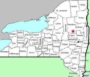
County: |
Hamilton |
|
Town: |
Benson |
|
USGS Map: |
Three Ponds Mt |
|
Waterway: |
West Stony Creek North Branch |
|
Latitude: |
N 43° 16' 06" |
|
Longitude: |
W 74° 21' 47" |
|
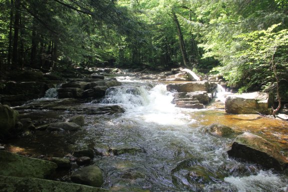
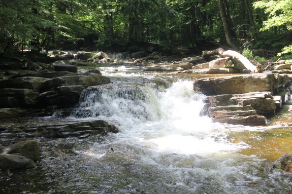
Drop: |
6' |
|
Type: |
Segmented cascade |
|
Region: |
Off NY 30 between Northville and Wells |
|
Parking: |
Unpaved lot |
|
Trail type: |
Dirt |
|
Length of hike: |
1.9 miles, one-way |
|
Difficulty: |
Moderate |
|
Accessibility: |
Easement |
|
Name: |
Common |
|
 If
you are not familiar with this area, it can be confusing.
Although the parking area is labeled as trailhead parking, this
is not the trailhead. After parking, walk down the road
about 200 yards. You will come to a sign-in box.
This is considered the trailhead but you are still a short
distance from the trail! If
you are not familiar with this area, it can be confusing.
Although the parking area is labeled as trailhead parking, this
is not the trailhead. After parking, walk down the road
about 200 yards. You will come to a sign-in box.
This is considered the trailhead but you are still a short
distance from the trail!
Continue walking down the road and you will come to a private
camp. To the right behind this is a gate to an access
road. The beginning, and actually most of the trail, is
this easement road. Posted signs mark both sides of the
road but you are on the trail as long as you stay on the road.
Yellow disk markers point your way for 1.3 miles where you will
come to a clearing at the creek. At this point, head left
toward Rock Lake.
Yellow disk markers point your way for 1.3 miles where you will
come to a clearing at the creek. At this point, head left toward
Rock Lake. It is roughly another 1/2 mile to the falls from
here.
There is a clearing at the falls and a little further upstream
there is a foot bridge over the creek. There is also a
shorter drop upstream of the main falls, just below the
footbridge.
Note: We saw signs in the area identifying this
waterway as the West Stoney Creek.
The West Stony Creek North Branch flows into the West Stony Creek
about five miles from this location. That empties into the
Sacandaga River just north of Northville. The Sacandaga Flows
through the Great Sacandaga Lake and merges with the Hudson River
in Lake Luzerne. The Hudson empties into the Atlantic Ocean
in New York City.
Last update: August 5, 2021
|