| Directions
The Blake Road is a dead-end road off
the Raquette River Road, east of the hamlet of South Colton,
it runs for several miles. This site would have been
a short distance up the Blake Road.
|
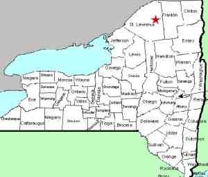
| County: |
St. Lawrence |
| Town: |
Parishville |
| USGS Map: |
Rainbow Falls |
| Waterway: |
Raquette River |
| Latitude: |
N 44° 30'
17" |
| Longitude: |
W 74°
45' 27" |
| Drop: |
NA |
| Type: |
Historical |
| Region: |
Off NY 56,
east of South Colton |
| Parking: |
NA |
| Trail type: |
NA |
| Length of hike: |
NA |
| Difficulty: |
NA |
| Accessibility: |
NA |
| Name: |
Official |
|
There are dozens of power dams that now dot the Raquette River
in this section. Many of the dams are at locations of waterfalls
and some of them have replaced the waterfall that used to be there.
This is a slightly different situation.
Little Falls is one of three historical waterfalls in this area
listed by the United States Geological Survey (USGS) Geographic
Names Information System (GNIS). This former waterfall is
just downstream of the power plant at Blake Falls Dam. It
is in the channel of the Raquette River between Rainbow Falls Reservoir
and Blake Falls Reservoir.
The Raquette River empties into the St. Lawrence River in Massena,
New York.
Last update: July 26, 2016
|


