| Directions
This waterfall is in the village of Philadelphia.
From the intersection of US 11 and NY 26, follow NY 26 north
for only 250 feet or so. The first left is Garden
Road. You will cross a bridge and the upper falls
will be on the left. Just past here is the Village
of Philadelphia Wastewater Collection and Treatment Facility.
|
| County: |
Jefferson |
| Town: |
Philadelphia |
| USGS Map: |
Philadelphia |
| Waterway: |
Indian River |
| Latitude: |
44° 09' 33" |
| Longitude: |
75° 42' 34" |
| Drop: |
NA |
| Type: |
Multi-step |
| Region: |
In the village of Philadelphia |
| Parking: |
Roadside |
| Trail type: |
Dirt |
| Length of hike: |
0.1 mile |
| Difficulty: |
Easy |
| Accessibility: |
Public |
| Name: |
Common |
|
This is a very interesting
location. There are four distinct drops here. Just
below a hydro dam, there is a pleasant little waterfall which we
are referring to as Philadelphia Upper Falls. You can see
this easily from Garden Road. Below this there are
actually three drops, formed where the river divides around two islands.
At the bottom of these drops, there are at least two other
islands.
You can see two of these three lower drops from
the property of the Philadelphia Wastewater Collection and
Treatment Facility. Given its name, we assume it is a
public facility. The last time we were there, workers
directed us to where we could get pictures. Your best view
is of the center channel. The right channel appears to be
best viewed from a canoe or kayak in the river downstream of it
or by wading through the creeks formed by the islands.
There are nice views of the left channel, but pictures are
limited because of the chain-link fence around it.
Even
though this is technically one waterfall location, to do justice
to all four drops, which all have their own personality, we are
providing four pages. Please visit
Philadelphia Upper Falls,
Philadelphia Right Falls,
Philadelphia Center Falls
and Philadelphia Left Falls.
Since these drops are just downstream of an active hydro
electric generation plant, the flow here can be affected by the
production. We have been there during production times.
The Upper Falls was very weak. The Left Falls was totally
dry and the Middle Falls was close to it. The Left Falls
was the only one with significant water.
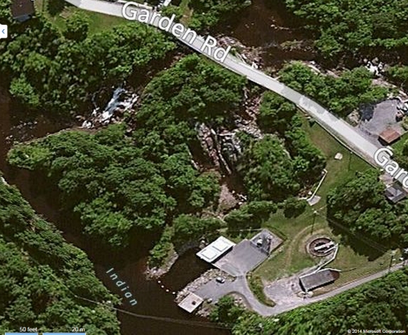
We have provided an image from bingmaps.com to show the
geography of the area.The Indian River flows through Black Lake. Then it joins
the Oswegatchie River which flows to the St. Lawrnce River in Ogdensburg.
Last update: April 14, 2017
|